Situated in Endla Nature Reserve. To organise a public event with more than 20 participants, drive an off-road vehicle and go on a boating trip, a permit must be obtained from the protected area manager. Further information can be obtained from the Environmental Board +372 662 5999, info@keskkonnaamet.ee
Contact
Telephone: +372 676 7030
E-mail: info.elistvere@rmk.ee
Object type: campfire site
Location info
Location : Järva County, Endla Nature Reserve
Järva municipality, Järva County
Navigation instructions : On Tallinn–Tartu road at Mäeküla junction turn towards Koeru (sign “Koeru 34 km”). Just before Koeru take a turn to the right (follow the sign “Norra-Oostriku allikad 7 km”). Drive 11.8 km and turn left (follow the sign “Kirikumäe lõkkekoht”) and then drive 2.6 km to the Põltsamaa River.
By clicking on the map it will open the map application larger in a new window.
Telephone:
+372 676 7030
E-mail:
info.elistvere@rmk.ee
Object type:
campfire site
Location info
Location:
Järva County, Endla Nature Reserve
Järva municipality, Järva County
Navigation instructions:
On Tallinn–Tartu road at Mäeküla junction turn towards Koeru (sign “Koeru 34 km”). Just before Koeru take a turn to the right (follow the sign “Norra-Oostriku allikad 7 km”). Drive 11.8 km and turn left (follow the sign “Kirikumäe lõkkekoht”) and then drive 2.6 km to the Põltsamaa River.
A windswept rest stop at the tip of Diby peninsula, offering beautiful views of nature and the sea. Diby rest stop is home to a closed former Soviet border guard observation post. A variety of domestic orchids can be found growing in the sparse alvar forest of Diby peninsula, including the beautiful slipper orchid and the narreaved helleborine, with its calcareous grasslands being home to the fly orchid and the musk orchid.
The roadside campfire site is suitable for relaxation and having a picnic. The shelter of the campfire site provides protection from rain and winds for 8-10 people. The Harimäe observation tower (27.5 m) next to the campfire site offers stunning views of Otepää, Valga slope and Karula national park.
Sights
A scenic view of Southern Estonian landscape.
Camping
Maximum number of tents (for 4) allowed is 10.
Amenities
Outdoor fireplace, dry toilet, picnic shelter, information boards.
Parking facilities
Updated parking lots with 6+3 parking spaces (large and small parking lots).
About restrictions please read here. Further information can be obtained from the Environmental Board info@keskkonnaamet.ee, +372 662 5999
Contact
Telephone: +372 676 7122
E-mail: info.kiidjarve@rmk.ee
Object type: campfire site
Location info
Location : Valga County, Otepää Nature Park
Mäeküla village, Sangaste municipality, Valga County.
Navigation instructions : At the junction with traffic lights in Otepää, choose Otepää–Kääriku–Kurevere road (Road no. 23195), drive 11 km to Kääriku and continue 2.8 km on the same road (turns into a gravel road). The campfire site is near the tower, by the left side of the road, follow the brown arrow signs to the tower.
By clicking on the map it will open the map application larger in a new window.
Telephone:
+372 676 7122
E-mail:
info.kiidjarve@rmk.ee
Object type:
campfire site
Location info
Location:
Valga County, Otepää Nature Park
Mäeküla village, Sangaste municipality, Valga County.
Navigation instructions:
At the junction with traffic lights in Otepää, choose Otepää–Kääriku–Kurevere road (Road no. 23195), drive 11 km to Kääriku and continue 2.8 km on the same road (turns into a gravel road). The campfire site is near the tower, by the left side of the road, follow the brown arrow signs to the tower.
Located in Piusa Cave Nature Reserve. Further information can be obtained from the Environmental Board +372 662 5999, info@keskkonnaamet.ee
Public transport
It is possible to come by train to the Piusa railway station stop, 50 m from the start of the track. Train departure times can be found at www.elron.ee. It is worth checking the times for a specific day.
Contact
Telephone: +372 676 7122
E-mail: info.kiidjarve@rmk.ee
Object type: hiking trail
Location info
Location : Võru County, Piusa Caves Nature Reserve
Võru municipality, Võru County
Navigation instructions : Drive along Räpina-Koidula Road and turn towards Põlva at Karisilla. Drive 7 km, then keep to the left towards Orava. Drive 10 km to Orava, turn left there towards Piusa. Continue for about 2.5 km until you get to Kliima, and them turn right towards Piusa. After about 3 km, the Piusa Cave Museum sign directs you to the left, and after 100 m you are there.
By clicking on the map it will open the map application larger in a new window.
Telephone:
+372 676 7122
E-mail:
info.kiidjarve@rmk.ee
Object type:
hiking trail
Location info
Location:
Võru County, Piusa Caves Nature Reserve
Võru municipality, Võru County
Navigation instructions:
Drive along Räpina-Koidula Road and turn towards Põlva at Karisilla. Drive 7 km, then keep to the left towards Orava. Drive 10 km to Orava, turn left there towards Piusa. Continue for about 2.5 km until you get to Kliima, and them turn right towards Piusa. After about 3 km, the Piusa Cave Museum sign directs you to the left, and after 100 m you are there.
VõimalusedStudy trailBack and forth trailYear-round maintenanceParking
Lääne County, Silma Nature Reserve
The most striking feature in Silma Nature Reserve is the reed beds. The Sutlepa Sea is a relict lake separated from the sea as a result of post-glacial rebound and its shores are hemmed with wide expanses of reeds. Here you can listen to the song of great reed warbler, the incessant reeling of Savi’s warbler, and the call of the Eurasian bittern, which resembles the sound of blowing in a bottle.
Sights
Lyckholm Manor and museum, coastal meadows, relict lakes
Amenities
The trail is marked with wooden signs, there’s an information board and an observation deck at the start of the trail. The further observation site is 380 m from the parking area. The trail also features an 7,5 m high Saare observation tower at the edge of the reeds.
Recreational fishing in Silma Nature Reserve is prohibited from 1 March to 30 June. Motorised water traffic is prohibited. Cycling outside designated roads and paths and motorised vehicle traffic and parking outside designated roads and parking areas is prohibited in the nature reserve. Camping and making campfire is allowed in designated places only.
Further information can be obtained from the Environmental Board +372 662 5999, info@keskkonnaamet.ee
Contact
Telephone: +372 506 2004
E-mail: info.nova@rmk.ee
Object type: study trail
Location info
Location : Lääne County, Silma Nature Reserve
Saare village, Lääne-Nigula municipality, Lääne County
Navigation instructions : Drive on Keila–Haapsalu road, turn right at Linnamäe. Drive 11 km, turn left towards Pürksi at the Aulepa junction. Before Pürksi village turn left (follow the sign to Lyckholm museum) and drive through Saare village. The road ends at the parking area and the lake, and this is where the study trail starts.
By clicking on the map it will open the map application larger in a new window.
Telephone:
+372 506 2004
E-mail:
info.nova@rmk.ee
Object type:
study trail
Location info
Location:
Lääne County, Silma Nature Reserve
Saare village, Lääne-Nigula municipality, Lääne County
Navigation instructions:
Drive on Keila–Haapsalu road, turn right at Linnamäe. Drive 11 km, turn left towards Pürksi at the Aulepa junction. Before Pürksi village turn left (follow the sign to Lyckholm museum) and drive through Saare village. The road ends at the parking area and the lake, and this is where the study trail starts.
VõimalusedStudy trailBack and forth trailYear-round maintenance
Lääne County, Silma Nature Reserve
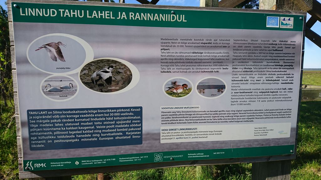
A marked out-and-back hiking trail from the former Tahu Manor Park. The observation tower at the end of the trail has been demolished and preparations are underway for the construction of a new one. The coastal areas here provide a suitable nesting place for many waders and, during migration, flocks of geese, brent geese, and swans stop here. It’s an exciting place to watch birds.
Sights
Coastal grasslands, relict lakes
Amenities
Information board and and observation tower at the end of the trail
Recreational fishing in Silma Nature Reserve is prohibited from 1 March to 30 June. Motorised water traffic is prohibited. Cycling outside designated roads and paths and motorised vehicle traffic and parking outside designated roads and parking areas is prohibited in the nature reserve. Camping and making campfire is allowed in designated places only.
Further information can be obtained from the Environmental Board +372 662 5999, info@keskkonnaamet.ee
Contact
Telephone: +372 506 2004
E-mail: info.nova@rmk.ee
Object type: study trail
Location info
Location : Lääne County, Silma Nature Reserve
Tahu village, Lääne-Nigula municipality, Lääne County
Navigation instructions : Drive on Keila–Haapsalu road, turn right at Linnamäe. Drive 11 km, turn left towards Pürksi at the Aulepa junction. Drive through Pürksi village 3.5 km along Tahu road to the parking area. Park your car and follow the 700 m path to the observation tower.
By clicking on the map it will open the map application larger in a new window.
Telephone:
+372 506 2004
E-mail:
info.nova@rmk.ee
Object type:
study trail
Location info
Location:
Lääne County, Silma Nature Reserve
Tahu village, Lääne-Nigula municipality, Lääne County
Navigation instructions:
Drive on Keila–Haapsalu road, turn right at Linnamäe. Drive 11 km, turn left towards Pürksi at the Aulepa junction. Drive through Pürksi village 3.5 km along Tahu road to the parking area. Park your car and follow the 700 m path to the observation tower.
VõimalusedHiking trail/Hiking OptionsObservation towerMaintenance during summerParking
Lääne County, Silma Nature Reserve
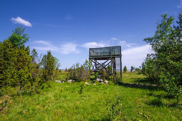
From this observation tower you can view with binoculars the birds swimming on the Sutlepa sea. During spring and autumn migration you can see thousands of aquatic birds stopping here (swans, ducks, aythyas, long-tailed ducks etc). On April and May nights you can hear the load low voice eurasian bittern from the reed, that is similar to blowing into a glass bottle. Over the sea you can see gliding the white-tailed eagle.
Recreational fishing in Silma Nature Reserve is prohibited from 1 March to 30 June. Motorised water traffic is prohibited. Cycling outside designated roads and paths and motorised vehicle traffic and parking outside designated roads and parking areas is prohibited in the nature reserve. Camping and making campfire is allowed in designated places only.
Further information can be obtained from the Environmental Board +372 662 5999, info@keskkonnaamet.ee
Contact
Telephone: +372 506 2004
E-mail: info.nova@rmk.ee
Object type: observation tower
Location info
Location : Lääne County, Silma Nature Reserve
Saare village, Lääne-Nigula municipality, Lääne County
Navigation instructions : From Tallinn: Drive to Keila. Start driving towards Haapsalu on the Keila-Haapsalu road and turn right at Linnamäe. Drive 11 km and turn left towards Pürksi from Aulepa crossroads. Before Pürksi turn left again (sign „Lyckholmi muuseum") and drive through Saare village. The road ends at the parking area by a lake. From the lake beings a study trail that takes you to the observation tower.
By clicking on the map it will open the map application larger in a new window.
Telephone:
+372 506 2004
E-mail:
info.nova@rmk.ee
Object type:
observation tower
Location info
Location:
Lääne County, Silma Nature Reserve
Saare village, Lääne-Nigula municipality, Lääne County
Navigation instructions:
From Tallinn: Drive to Keila. Start driving towards Haapsalu on the Keila-Haapsalu road and turn right at Linnamäe. Drive 11 km and turn left towards Pürksi from Aulepa crossroads. Before Pürksi turn left again (sign „Lyckholmi muuseum") and drive through Saare village. The road ends at the parking area by a lake. From the lake beings a study trail that takes you to the observation tower.
Suitable for a solitary wanderer interested in birds and nature. Beautiful view to the Tahu Bay. The road is not marked, it is necessary to bring a GPS device.
Sights
About 2 km south of the Võnnussaare observation tower, you can visit the largest glacial erratic boulder in north-western Estonia: the Truumann or Kalevipoeg boulder.
Recreational fishing in Silma Nature Reserve is prohibited from 1 March to 30 June. Motorised water traffic is prohibited. Cycling outside designated roads and paths and motorised vehicle traffic and parking outside designated roads and parking areas is prohibited in the nature reserve. Camping and making campfire is allowed in designated places only.
Further information can be obtained from the Environmental Board +372 662 5999, info@keskkonnaamet.ee
Contact
Telephone: +372 506 2004
E-mail: info.nova@rmk.ee
Object type: observation tower
Location info
Location : Lääne County, Silma Nature Reserve
Lääne-Nigula municipality, Lääne County
Navigation instructions : When driving along Keila-Haapsalu Road, turn right at Linnamäe. At the 11th kilometre sign, turn left onto Aulepa Road towards Pürksi. Before reaching Pürksi, turn left towards Saare Manor (there is a sign for the Lyckholm Museum). 100 metres before Saare Manor, turn right onto the road and drive 2.15 km to the parking pocket. Walk for 1.5 km on foot.
By clicking on the map it will open the map application larger in a new window.
Telephone:
+372 506 2004
E-mail:
info.nova@rmk.ee
Object type:
observation tower
Location info
Location:
Lääne County, Silma Nature Reserve
Lääne-Nigula municipality, Lääne County
Navigation instructions:
When driving along Keila-Haapsalu Road, turn right at Linnamäe. At the 11th kilometre sign, turn left onto Aulepa Road towards Pürksi. Before reaching Pürksi, turn left towards Saare Manor (there is a sign for the Lyckholm Museum). 100 metres before Saare Manor, turn right onto the road and drive 2.15 km to the parking pocket. Walk for 1.5 km on foot.
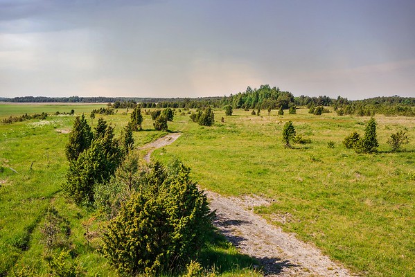
The Audaku study trail runs along the maximum height of the uplands of West-Saaremaa, through diverse forest communities. The landforms visible along the trail were formed around 9,500 years ago and are located about 50 metres above sea level. The varied relief and soil conditions found here have contributed to the formation of diverse forest habitats. Whatever the season, the Audaku trail has experiences to offer. In spring, before the trees have come into leaf, you can enjoy the abundance of flowers on the forest floor and birdsongs. In summer, it is worth stopping at the fen and wooded meadow, while the colourful broad-leafed forest can be enjoyed during autumn. In winter, mosses and lichens are clearly visible, as are the tracks of forest animals. It is possible to head from the study trail to the Audaku arboretum at the Tallinn Botanic Garden. The Audaku study trail is 2.3 km long and marked with red trail markers in nature.
Sights
The trail passes through communities characteristic of the West Saaremaa Uplands – various forest types, species rich fen patches, and restored wooded meadows.
Amenities
Boardwalks, 7 information boards
Parking
The car park can accommodate six cars or three minibuses.
Located in Viidumäe Nature Reserve. Further information can be obtained from the Environmental Board +372 662 5999, info@keskkonnaamet.ee
Contact
Telephone: +372 454 6880 +372 527 7421
E-mail: info.vilsandi@rmk.ee
Object type: study trail
Location info
Location : Saare County, Viidumäe Nature Reserve
Saaremaa municipality
Navigation instructions : Drive 73 km on Kuivastu–Kuressaare road, turn right onto the Kuressaare roundabout and drive 2.8 km to the next roundabout, exit towards Kihelkonna. Drive 12.6 km on Kuressaare–Kihelkonna–Veere road and turn left onto Käesla–Karala–Loona road. Drive 8.9 km and turn right, following the sign to Viidumäe Nature Reserve Centre. Drive 2.3 km on gravel road and turn right to the small parking area which marks the start of two trails introducing Viidumäe Nature Reserve—the Audaku hiking trail and the Viidumäe study trail.
By clicking on the map it will open the map application larger in a new window.
Telephone:
+372 454 6880 +372 527 7421
E-mail:
info.vilsandi@rmk.ee
Object type:
study trail
Location info
Location:
Saare County, Viidumäe Nature Reserve
Saaremaa municipality
Navigation instructions:
Drive 73 km on Kuivastu–Kuressaare road, turn right onto the Kuressaare roundabout and drive 2.8 km to the next roundabout, exit towards Kihelkonna. Drive 12.6 km on Kuressaare–Kihelkonna–Veere road and turn left onto Käesla–Karala–Loona road. Drive 8.9 km and turn right, following the sign to Viidumäe Nature Reserve Centre. Drive 2.3 km on gravel road and turn right to the small parking area which marks the start of two trails introducing Viidumäe Nature Reserve—the Audaku hiking trail and the Viidumäe study trail.
VõimalusedRest stopObservation towerMaintenance during summerParking
Saare County, Viidumäe Nature Reserve
The former forest watch tower, nearly 30 m high, on Raunamägi hill in the highest part of Saaremaa.
Sights
Enjoy the stunning views over the entire western part of the Saaremaa Island from the observation tower on the Rauna hill, the highest peak along the “backbone” of the island (54 m above sea level).
6 visitors are allowed in the observation tower at the same time. Children are allowed in the tower only under adult supervision.
Located in Viidumäe Nature Reserve. Further information can be obtained from the Environmental Board +372 662 5999, info@keskkonnaamet.ee
Contact
Telephone: +372 454 6880 +372 527 7421
E-mail: info.vilsandi@rmk.ee
Object type: observation tower
Location info
Location : Saare County, Viidumäe Nature Reserve
Lümanda village, Saaremaa municipality
Navigation instructions : Drive from Kuivastu on Road no. 10 to the Kuressaare roundabout and turn right. Drive 4 km to the next roundabout and exit onto Road no. 78. Drive 13 km to the junction towards Lümanda and turn left, drive 9 km to the Viidu bus stop and turn right onto the gravel road to Viidu village. Drive 2 km to the observation tower to your left.
By clicking on the map it will open the map application larger in a new window.
Telephone:
+372 454 6880 +372 527 7421
E-mail:
info.vilsandi@rmk.ee
Object type:
observation tower
Location info
Location:
Saare County, Viidumäe Nature Reserve
Lümanda village, Saaremaa municipality
Navigation instructions:
Drive from Kuivastu on Road no. 10 to the Kuressaare roundabout and turn right. Drive 4 km to the next roundabout and exit onto Road no. 78. Drive 13 km to the junction towards Lümanda and turn left, drive 9 km to the Viidu bus stop and turn right onto the gravel road to Viidu village. Drive 2 km to the observation tower to your left.