The campfire site is situated in Alam-Pedja Nature Reserve. Further information can be obtained from the Environmental Board +372 662 5999, info@keskkonnaamet.ee
Contact
Telephone: +372 676 7122
E-mail: info.kiidjarve@rmk.ee
Object type: campfire site
Location info
Location : Viljandi County, Alam-Pedja Nature Reserve
By the Pede River, Viljandi municipality, Viljandi County
Navigation instructions : Watercraft can be launched in the river Emajõgi at Jõesuu by Lake Võrtsjärv, move 7 km downstream and turn into the Pede River. Continue for about 2 km upstream along the river.
By clicking on the map it will open the map application larger in a new window.
Telephone:
+372 676 7122
E-mail:
info.kiidjarve@rmk.ee
Object type:
campfire site
Location info
Location:
Viljandi County, Alam-Pedja Nature Reserve
By the Pede River, Viljandi municipality, Viljandi County
Navigation instructions:
Watercraft can be launched in the river Emajõgi at Jõesuu by Lake Võrtsjärv, move 7 km downstream and turn into the Pede River. Continue for about 2 km upstream along the river.
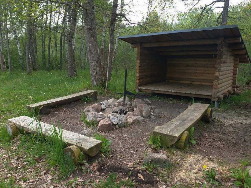
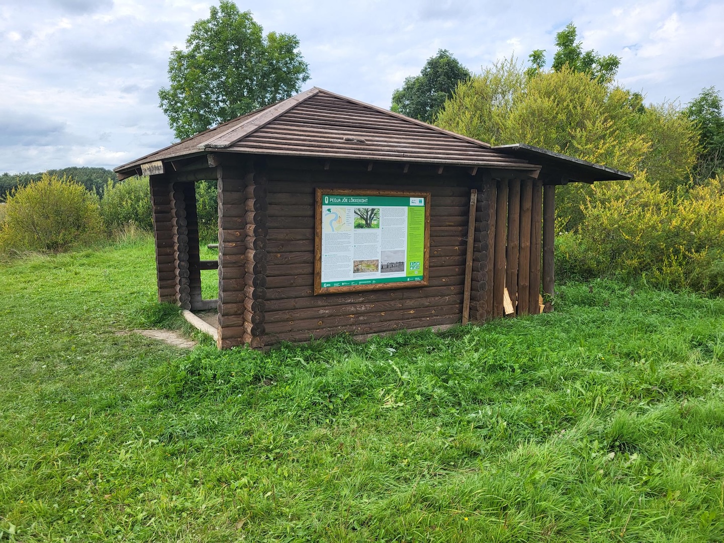
A campfire site on the right bank of the Pede river, for hikers travelling by water. In the forest hut here they can have a rest before continuing their journey on the river Emajõgi.
Sights
Pede River and the natural riverside landscape.
Amenities
Campfire site, lean-to, table, benches, dry toilet, information board.
Parking
Boat landing in a natural place.
Additional information
During floods the campfire site may be under water. Please take all waste with you when you leave.
Located in Nature Reserve. Further information can be obtained from the Environmental Board +372 662 5999, info@keskkonnaamet.ee
Contact
Telephone: +372 676 7122
E-mail: info.kiidjarve@rmk.ee
Object type: campfire site
Location info
Location : Viljandi County, Alam-Pedja Nature Reserve
By the Pede River, Viljandi municipality, Viljandi County
Navigation instructions : Watercraft can be launched in the river Emajõgi at Jõesuu by Lake Võrtsjärv, move 7 km downstream and turn into the Pede River. Continue for about 3 km upstream along the river.
By clicking on the map it will open the map application larger in a new window.
Telephone:
+372 676 7122
E-mail:
info.kiidjarve@rmk.ee
Object type:
campfire site
Location info
Location:
Viljandi County, Alam-Pedja Nature Reserve
By the Pede River, Viljandi municipality, Viljandi County
Navigation instructions:
Watercraft can be launched in the river Emajõgi at Jõesuu by Lake Võrtsjärv, move 7 km downstream and turn into the Pede River. Continue for about 3 km upstream along the river.
Hiking trail/Hiking OptionsCampingFireplaceMaintenance during summer
Jõgeva County, Alam-Pedja Nature Reserve
The campfire site is in the lands of the old Altmetsa farm, 1,5 km from the parking lot of Kirna study trail. The observation tower at the campfire site is visible from the very start of Kirna study trail and it offers a good view on the Pedja river and flooded meadow.
Altmetsa 4-storey watchtower (14 m), campfire site with grill rest, 6 benches, dry toilet, information board
Parking
Parking for 8 cars is at he beginning of the trail before the bridge over the Pedja River.
Additional information
Kirna study trail, which takes you to the campfire site, can be impassable during the flood. On the trail and at the campfire site gun shots can be heard – this is because of the shooting practice of the Defence League.
The campfire site is situated in Alam-Pedja Nature Reserve. Further information can be obtained from the Environmental Board +372 662 5999, info@keskkonnaamet.ee
Contact
Telephone: +372 676 7122
E-mail: info.kiidjarve@rmk.ee
Object type: campfire site
Location info
Location : Jõgeva County, Alam-Pedja Nature Reserve
Põltsamaa municipality, Jõgeva County
Navigation instructions : To get to Kirna study trail, drive along the Tartu–Tallinn road, 30 km from Tartu, turn left in Puurmani towards Jüriküla (there are 2 signs under the bridge – “Kirna 5” and “Jüriküla keskus”) and drive 5 km till the parking lot of Kirna study trail. Continue on foot 1,5 km through the Pedja river campfire site or 5,5 km from the direction of Defence League. Access by boat along the Pedja River, heading downstream from the bridge untill the tower.
By clicking on the map it will open the map application larger in a new window.
Telephone:
+372 676 7122
E-mail:
info.kiidjarve@rmk.ee
Object type:
campfire site
Location info
Location:
Jõgeva County, Alam-Pedja Nature Reserve
Põltsamaa municipality, Jõgeva County
Navigation instructions:
To get to Kirna study trail, drive along the Tartu–Tallinn road, 30 km from Tartu, turn left in Puurmani towards Jüriküla (there are 2 signs under the bridge – “Kirna 5” and “Jüriküla keskus”) and drive 5 km till the parking lot of Kirna study trail. Continue on foot 1,5 km through the Pedja river campfire site or 5,5 km from the direction of Defence League. Access by boat along the Pedja River, heading downstream from the bridge untill the tower.
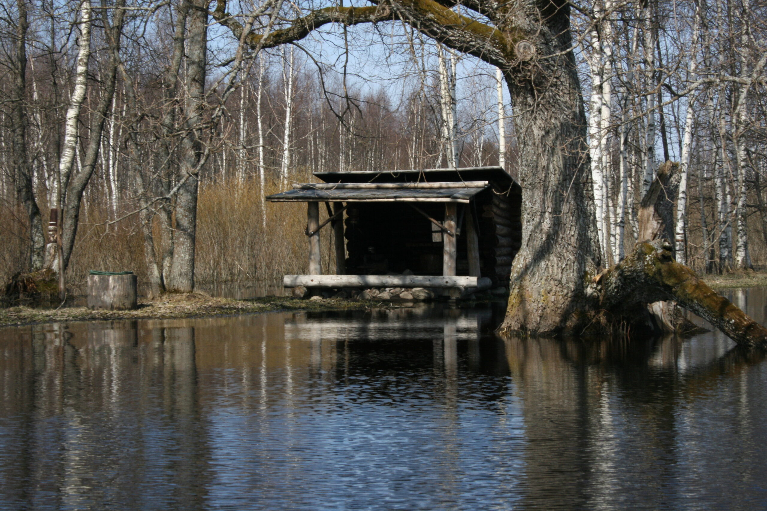
Pedja river campfire site is a well-known rest stop for travellers by water and a pleasant rest stop for hikers on Kirna study trail.
Sights
Pedja River, floodplain area and rich biota.
Hiking options
On the Kirna study trail.
Camping
Maximum number of tents (for 4) allowed is 6.
Amenities
Campfire site with grill rest, shelter, 4 benches, 2 dry toilets
Parking
Parking area for 8 cars before the bridge over the Pedja River.
Additional information
During the flood the campfire site may be under water. If you want to make campfire, please bring firewood with you (making a campfire is allowed only in prepared and designated places). Take all waste with you when you leave. At the campfire site gun shots can be heard – this is because of the shooting practice of the Defence League.
The campfire site is situated in Alam-Pedja Nature Reserve, view the restrictions on visiting here.Further information can be obtained from the Environmental Board +372 662 5999, info@keskkonnaamet.ee
Contact
Telephone: +372 676 7122
E-mail: info.kiidjarve@rmk.ee
Object type: campfire site
Location info
Location : Jõgeva County, Alam-Pedja Nature Reserve
Puurmani municipality, Jõgeva County
Navigation instructions : Pedja River campfire site is at the end of Kirna study trail by the Pedja River. To get to Kirna study trail, drive along the Tartu-Tallinn road, 30 km from Tartu in Puurmani turn left towards Jüriküla (there are 2 signs under the bridge – “Kirna 5” and “Jüriküla keskus”) and drive 5 km. Turn right before the bridge over the Pedja River. The parking area and information board are right by the road. Pedja River campfire site is on the riverbank 50 m from the parking lot.
By clicking on the map it will open the map application larger in a new window.
Telephone:
+372 676 7122
E-mail:
info.kiidjarve@rmk.ee
Object type:
campfire site
Location info
Location:
Jõgeva County, Alam-Pedja Nature Reserve
Puurmani municipality, Jõgeva County
Navigation instructions:
Pedja River campfire site is at the end of Kirna study trail by the Pedja River. To get to Kirna study trail, drive along the Tartu-Tallinn road, 30 km from Tartu in Puurmani turn left towards Jüriküla (there are 2 signs under the bridge – “Kirna 5” and “Jüriküla keskus”) and drive 5 km. Turn right before the bridge over the Pedja River. The parking area and information board are right by the road. Pedja River campfire site is on the riverbank 50 m from the parking lot.
The recommended start of the journey is behind the dam on Kamari water reservoir. The water trail is 75 km long. The journey may take 2-3 days. The water trail is meant to be completed by non-motorised watercraft.
Sights
Põltsamaa River, Pede River and the River Emajõgi, the natural riverside landscape and key habitats.
Camping
Camping is allowed in Naela and Rasti campfire sites.
Amenities
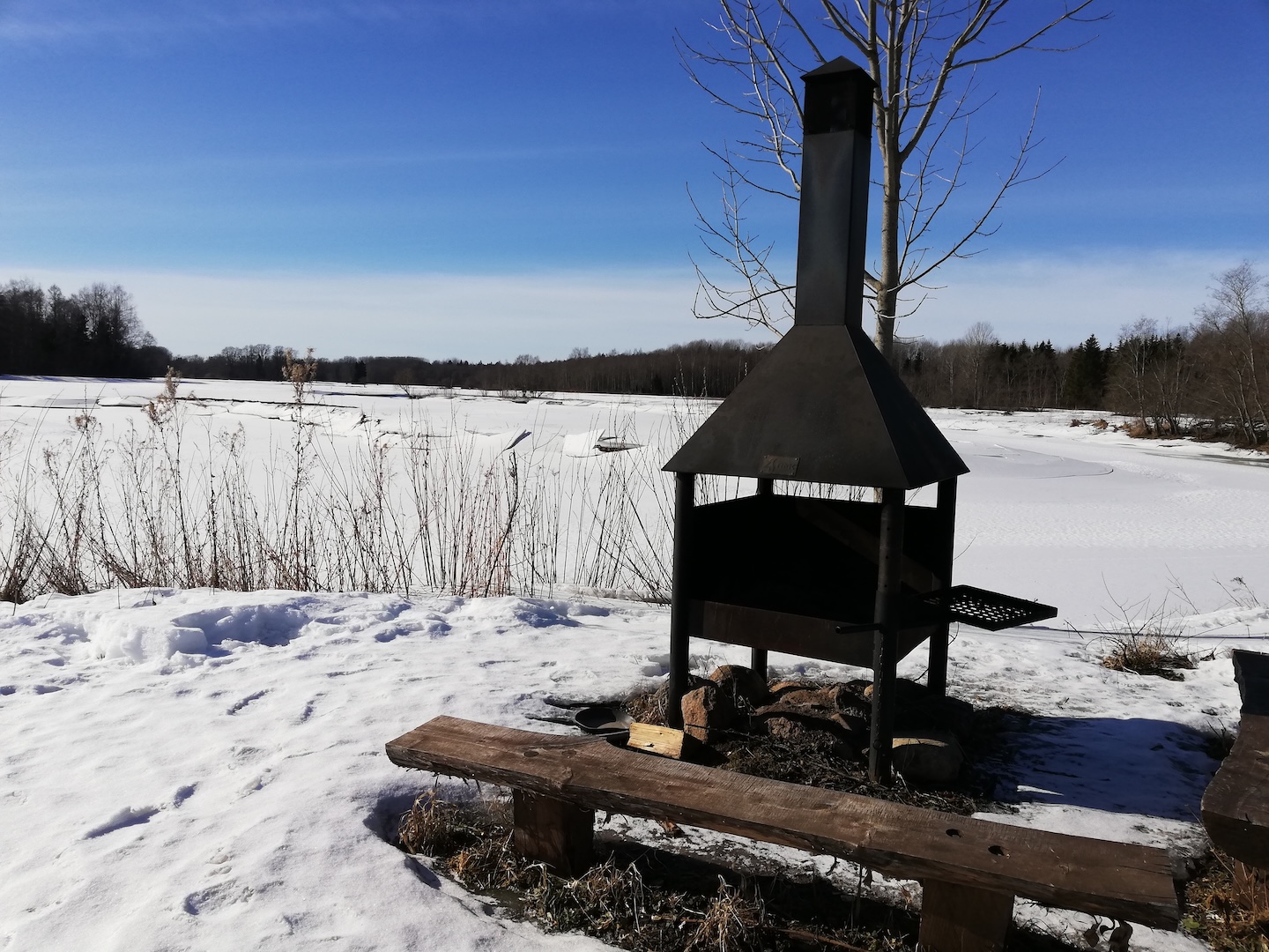
RMK Rasti and Naela campfire sites. If you want to make campfire, please bring firewood with you.
Parking
Kamari parking area. Boat landing in a natural place.
Additional information
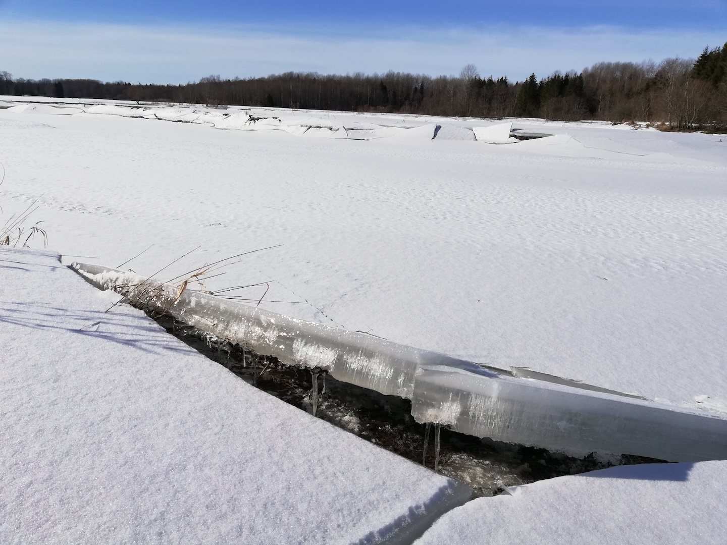
Kamari–Kärevere water trail goes along the Põltsamaa River, the Pede River and the river Emajõgi (in the open water period). The water trail gives an opportunity to travel on the rivers of the Nature Reserve. Please note that the river Emajõgi is a navigable waterway, while other rivers are natural. In certain places it may be complicated to pass through natural rivers. Please note that watercraft launching and landing places are not marked or designated. Please take all waste with you when you leave.
The water trail is situated in Alam-Pedja Nature Reserve. Further information can be obtained from the Environmental Board +372 662 5999, info@keskkonnaamet.ee
Contact
Telephone: +372 676 7122
E-mail: info.kiidjarve@rmk.ee
Object type: hiking trail
Location info
Location : Jõgeva County, Alam-Pedja Nature Reserve
Kamari (Põltsamaa municipality, Jõgeva County) – Laashoone (Viljandi municipality, Viljandi County) – Palupõhja, Reku, Kärevere, Tartu municipality
Navigation instructions : Please note that the watercraft launching and landing places and the water trail are not marked or designated. This is a natural trail, where hikers must be ready to find the necessary solutions and possibilities themselves. Hikers can launch their boat after the dam of Kamari reservoir (Väike-Kamari village, Põltsamaa municipality, Jõgeva County) and land at Kärevere bridge (Leetsi village, Tähtvere municipality, Tartu County). If necessary, please ask for help or directions from RMK Ranger at +372 5811 8500.
Telephone:
+372 676 7122
E-mail:
info.kiidjarve@rmk.ee
Object type:
hiking trail
Location info
Location:
Jõgeva County, Alam-Pedja Nature Reserve
Kamari (Põltsamaa municipality, Jõgeva County) – Laashoone (Viljandi municipality, Viljandi County) – Palupõhja, Reku, Kärevere, Tartu municipality
Navigation instructions:
Please note that the watercraft launching and landing places and the water trail are not marked or designated. This is a natural trail, where hikers must be ready to find the necessary solutions and possibilities themselves. Hikers can launch their boat after the dam of Kamari reservoir (Väike-Kamari village, Põltsamaa municipality, Jõgeva County) and land at Kärevere bridge (Leetsi village, Tähtvere municipality, Tartu County). If necessary, please ask for help or directions from RMK Ranger at +372 5811 8500.
Study trailCircular trailCampingFireplaceYear-round maintenanceParking
Jõgeva County, Alam-Pedja Nature Reserve
Kirna study trail gives an excellent opportunity to get familiar with the meadows and floodplain forest of the Pedja river. To get a better overview of the flood meadows and the river, an observation tower has been built at Altmetsa farmstead. Further on the trail there is a suspension bridge across the river.
Sights
Pedja River, flooded areas, floodplain forest and wooded meadow. The majestic oak tree Musutamm stands on the right bank of the Pedja River. In several places signs of wild boar and beaver activity can be seen.
Camping
At the Pedja River and Altmetsa campfire sites.
Amenities
Parking area, 15 information boards, 10 bridges, 1 suspension bridge.
Parking
Parking area for 8 cars before the bridge over the Pedja River.
On the trail you can hear the gunshots accompanying the shooting exercises of the Defense League
The access roads to the meadows intersect with the study trail in several places, please follow the indication of the trail.
Cattle also help to maintain the meadows, please keep a safe distance from electric shepherds!
Restrictions
The study trail is situated in Alam-Pedja Nature Reserve, view the restrictions on visiting here. Camping and making campfire are only allowed in prepared and marked places. Further information about restrictions can be obtained from the Environmental Board +372 662 5999, info@keskkonnaamet.ee
Contact
Telephone: +372 676 7122
E-mail: info.kiidjarve@rmk.ee
Object type: study trail
Location info
Location : Jõgeva County, Alam-Pedja Nature Reserve
Põltsamaa municipality, Jõgeva County
Navigation instructions : Drive along the Tartu-Tallinn road, 30 km from Tartu, turn left in Puurmani towards Jüriküla (there are 2 signs under the bridge – “Kirna 5” and “Jüriküla keskus”) and drive 5 km. Before the bridge over the Pedja River, there is a parking area and information board. The study trail starts here.
By clicking on the map it will open the map application larger in a new window.
Telephone:
+372 676 7122
E-mail:
info.kiidjarve@rmk.ee
Object type:
study trail
Location info
Location:
Jõgeva County, Alam-Pedja Nature Reserve
Põltsamaa municipality, Jõgeva County
Navigation instructions:
Drive along the Tartu-Tallinn road, 30 km from Tartu, turn left in Puurmani towards Jüriküla (there are 2 signs under the bridge – “Kirna 5” and “Jüriküla keskus”) and drive 5 km. Before the bridge over the Pedja River, there is a parking area and information board. The study trail starts here.
Study trailCircular trailYear-round maintenanceParking
Tartu County, Alam-Pedja Nature Reserve
The forest trail takes the hikers on a pilgrimage to the edge of Laeva Bog, where the Suurtüki observation tower offers magnificent views of the surrounding area. From there, the route alternates between a boardwalk and a dirt road as it crosses the bog its islands, which are at different stages of development. Information boards along the study trail introduce visitors to the bog’s nature and cultural heritage. The 4.7 km circular trail runs through the bog and forest for 3.5 km, and along the Laeva-Palupõhja gravel road for 1.2 km. The trail is for walking only!
Sights
Mire, varied biota.
Amenities
2 information boards, 2 shelters, 2 dry toilets, 3 benches, 9 small information boards, observation tower (12 m), boardwalks and wood chip-covered sections of the trail.
Parking
For 4 cars by the first shelter and for 8 cars in the parking lot 1 km away.
Additional information
The trail is for walking. On average it takes 1.5 h to walk the trail. The trail runs through the bog (3.5 km) and on gravel road (1.2 km).
The study trail is situated in Alam-Pedja Nature Reserve. Further information can be obtained from the Environmental Board +372 662 5999, info@keskkonnaamet.ee
Contact
Telephone: +372 676 7122
E-mail: info.kiidjarve@rmk.ee
Object type: study trail
Location info
Location : Tartu County, Alam-Pedja Nature Reserve
Tartu municipality, Tartu County
Navigation instructions : Drive along the Tartu–Tallinn road, 20 km from Tartu turn left immediately after the large sign (Tallinn 161, Siniküla 5, Laeva 2), drive 200 m and take the middle road to Palupõhja (traffic sign “uneven road” 11 km). Drive 7 km to the shelter and parking space on the right. Larger car park is after 1 km (BL: 58.435041, 26.268727, L-EST 97 x: 6479429 y: 632492).
By clicking on the map it will open the map application larger in a new window.
Telephone:
+372 676 7122
E-mail:
info.kiidjarve@rmk.ee
Object type:
study trail
Location info
Location:
Tartu County, Alam-Pedja Nature Reserve
Tartu municipality, Tartu County
Navigation instructions:
Drive along the Tartu–Tallinn road, 20 km from Tartu turn left immediately after the large sign (Tallinn 161, Siniküla 5, Laeva 2), drive 200 m and take the middle road to Palupõhja (traffic sign “uneven road” 11 km). Drive 7 km to the shelter and parking space on the right. Larger car park is after 1 km (BL: 58.435041, 26.268727, L-EST 97 x: 6479429 y: 632492).
Altmetsa observation tower (ca 1.5 km from the parking)
Võimalused
Hiking trail/Hiking OptionsObservation towerFireplaceMaintenance during summerParking
Jõgeva County, Alam-Pedja Nature Reserve
Altmetsa observation tower is located on the circular Kirna study trail. The tower is 1.5 km from the parking lot along the right branch of the trail and 5.3 km along the left branch. The so-called watchtower-type massive log tower, is located on the Altmetsa campfire site on the former farm land. From the observation tower, you can enjoy pleasant views of the Pedja River and the meadows. In case of heavy rainfall, it is difficult to pass through several sections of the trail leading to the campfire site, in some places the trail may be under water.
12 m high log observation tower, informnation boards on the walls of the intermediate platforms, tables and benches above
Parking
The parking lot for 8 cars is located at the beginning of the Kirna study trail before the Pedja river bridge
Additional information
Kirna study trail can be impassable during the flood. On the trail gun shots can be heard – this is because of the shooting practice of the Defence League.
The tower is situated in Alam-Pedja Nature Reserve. Further information can be obtained from the Environmental Board +372 662 5999, info@keskkonnaamet.ee
Contact
Telephone: +372 676 7122
E-mail: info.kiidjarve@rmk.ee
Object type: observation tower
Location info
Location : Jõgeva County, Alam-Pedja Nature Reserve
Põltsamaa municipality, Jõgeva County
Navigation instructions :The observation tower location marker on the map shows the location of the trail's parking lot. By land: drive along the Tartu–Tallinn road, 30 km from Tartu, turn left in Puurmani towards Jüriküla (there are 2 signs under the bridge – “Kirna 5” and “Jüriküla keskus”) and drive 5 km till the parking lot of Kirna study trail. Continue on foot 1,5 km through the Pedja river campfire site Access by boat: along the Pedja River, heading downstream from the bridge untill the tower.
By clicking on the map it will open the map application larger in a new window.
Telephone:
+372 676 7122
E-mail:
info.kiidjarve@rmk.ee
Object type:
observation tower
Location info
Location:
Jõgeva County, Alam-Pedja Nature Reserve
Põltsamaa municipality, Jõgeva County
Navigation instructions:
The observation tower location marker on the map shows the location of the trail's parking lot. By land: drive along the Tartu–Tallinn road, 30 km from Tartu, turn left in Puurmani towards Jüriküla (there are 2 signs under the bridge – “Kirna 5” and “Jüriküla keskus”) and drive 5 km till the parking lot of Kirna study trail. Continue on foot 1,5 km through the Pedja river campfire site Access by boat: along the Pedja River, heading downstream from the bridge untill the tower.
Built from massive logs, the so-called watchtower is located on the circular Selli-Sillaotsa study trail at the edge of Laeva Bog, on land that was once part of Suuretüki Farm. At different times of the year, the tower provides atmospheric views of the bog and the boardwalk running through it. Starting from the first car park on the right-hand side of the trail, the observation tower is 1 km away. Alternatively, if you follow the gravel road on the left-hand side of the trail, the tower is 3.7 km away. Heading from the second car park to the boardwalk, it is 2.5 km to the tower.
Sights
Views from the tower, wildlife, different wetland types, bog islets
Hiking options
On foot on Selli-Sillaotsa study trail
Amenities
12 m high log observation tower, informnation boards on the walls of the intermediate platforms, tables and benches above.
Parking
There is space for 4 cars near the first shelter and for 8 cars in another parking lot 1 km away.
Additional information
The trail is for walking. On average it takes 1.5 h to walk the trail. The trail runs through the bog (3.5 km) and on gravel road (1.2 km)
The tower is situated in Alam-Pedja Nature Reserve, view the restrictions on visiting here
Further information can be obtained from the Environmental Board +372 662 5999, info@keskkonnaamet.ee
Contact
Telephone: +372 676 7122
E-mail: info.kiidjarve@rmk.ee
Object type: observation tower
Location info
Location : Tartu County, Alam-Pedja Nature Reserve
Tartu municipality, Tartu County
Navigation instructions : Drive along the Tartu–Tallinn road, 20 km from Tartu turn left immediately after the large sign (Tallinn 161, Siniküla 5, Laeva 2), drive 200 m and take the middle road to Palupõhja (traffic sign “uneven road” 11 km). Drive 7 km to the shelter and parking space on the right. Larger car park is after 1 km.
By clicking on the map it will open the map application larger in a new window.
Telephone:
+372 676 7122
E-mail:
info.kiidjarve@rmk.ee
Object type:
observation tower
Location info
Location:
Tartu County, Alam-Pedja Nature Reserve
Tartu municipality, Tartu County
Navigation instructions:
Drive along the Tartu–Tallinn road, 20 km from Tartu turn left immediately after the large sign (Tallinn 161, Siniküla 5, Laeva 2), drive 200 m and take the middle road to Palupõhja (traffic sign “uneven road” 11 km). Drive 7 km to the shelter and parking space on the right. Larger car park is after 1 km.