The total length of Taagepera hiking trail is 5.4 km. The trail starts and ends at Taagepera campfire site, which offers a possibility of camping and making campfire. Traces of beaver activity, wood ants and rich forests – with larches, firs, oaks etc. – can be seen on the trail along the Õhne river. The trail can also be completed in shorter rounds of 1.6 km and 4.0 km. More precise trail information can be found on the board.
Sights
Taagepera Manor and park, Taagepera Church and graveyard, family burial place of the local barons, "Last Kiss", a sacrificial rock, underground cemetery, Õhne river.
The hill fort of Lõhavere was occupied by a local Estonian chieftain Lembitu during the Late Iron Age. It is one of the most thoroughly studied hill forts in Estonia. Major archaeological excavations have been conducted on the site since the late 19th century and almost two thirds of the stronghold has been excavated. Many of the stronghold’s details correspond to the description of the castle written in the Livonian Chronicle by a priest called Henry of Latvia in 1215. The stronghold has been built on a moraine hill which rises 8 to 10 meters above the surrounding terrain. Encircling the top of the hill is a man-made sand wall, which was originally supported from inside by a 2.5 meter timber wall. Timber structures were built on the top of the wall. The main gate of the hill fort was on the north side and was probably protected by a wooden tower.
Sights
A memorial “To the defenders of Sakala 1217-1223” designed by sculptor Renaldo Veeber and architect Ülo Stöör was opened in 1969.
Amenities
Gathering place with benches, information board and historical comic storyboards. A trail marked with arrows and a metal stair lead to the main gate of the hill fort. To return from the hill fort to the parking lot there is a wooden staircase.
Location : Viljandi County, Sakala Recreation Area
Lõhavere village, Põhja-Sakala municipality, Viljandi county
Navigation instructions : Drive 31 km along Imavere–Viljandi road and turn towards Vändra. Drive 6.8 km up to Suure-Jaani junction, where the sign “Lõhavere linnamägi 2 km” directs to the right. Drive about 2 km through Kõidama village and turn left, following the sign “Lõhavere linnamägi”. Drive about 1.1 km and you are there.
By clicking on the map it will open the map application larger in a new window.
Telephone:
+372 526 1924
E-mail:
info.soomaa@rmk.ee
Object type:
rest stop
Location info
Location:
Viljandi County, Sakala Recreation Area
Lõhavere village, Põhja-Sakala municipality, Viljandi county
Navigation instructions:
Drive 31 km along Imavere–Viljandi road and turn towards Vändra. Drive 6.8 km up to Suure-Jaani junction, where the sign “Lõhavere linnamägi 2 km” directs to the right. Drive about 2 km through Kõidama village and turn left, following the sign “Lõhavere linnamägi”. Drive about 1.1 km and you are there.
Located in Mukri Landscape Reserve. Further information can be obtained from the Environmental Board +372 662 5999, info@keskkonnaamet.ee
Contact
Telephone: +372 526 1924
E-mail: info.soomaa@rmk.ee
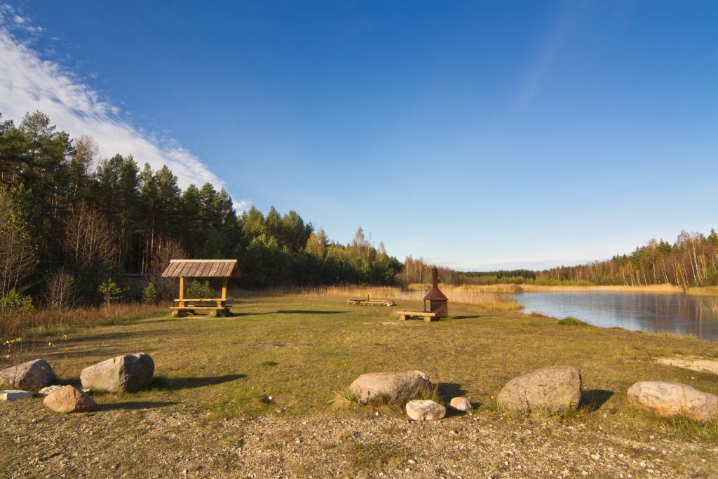
Object type: campfire site
Location info
Location : Rapla County, Mukri Nature Reserve
Mukri village, Kehtna municipality, Rapla County
Navigation instructions : From Tallinn: Drive to Rapla. From Rapla drive by Rapla-Türi road. From Lelle crossroads turn towards Eidapere and drive 15 km. From Eidapere turn left after the railroad crossing and drive 1.3 km. The campsite is on your right by the road.
By clicking on the map it will open the map application larger in a new window.
Telephone:
+372 526 1924
E-mail:
info.soomaa@rmk.ee
Object type:
campfire site
Location info
Location:
Rapla County, Mukri Nature Reserve
Mukri village, Kehtna municipality, Rapla County
Navigation instructions:
From Tallinn: Drive to Rapla. From Rapla drive by Rapla-Türi road. From Lelle crossroads turn towards Eidapere and drive 15 km. From Eidapere turn left after the railroad crossing and drive 1.3 km. The campsite is on your right by the road.
Located in Mukri Nature Reserve. Further information can be obtained from the Environmental Board +372 662 5999, info@keskkonnaamet.ee
Contact
Telephone: +372 526 1924
E-mail: info.soomaa@rmk.ee
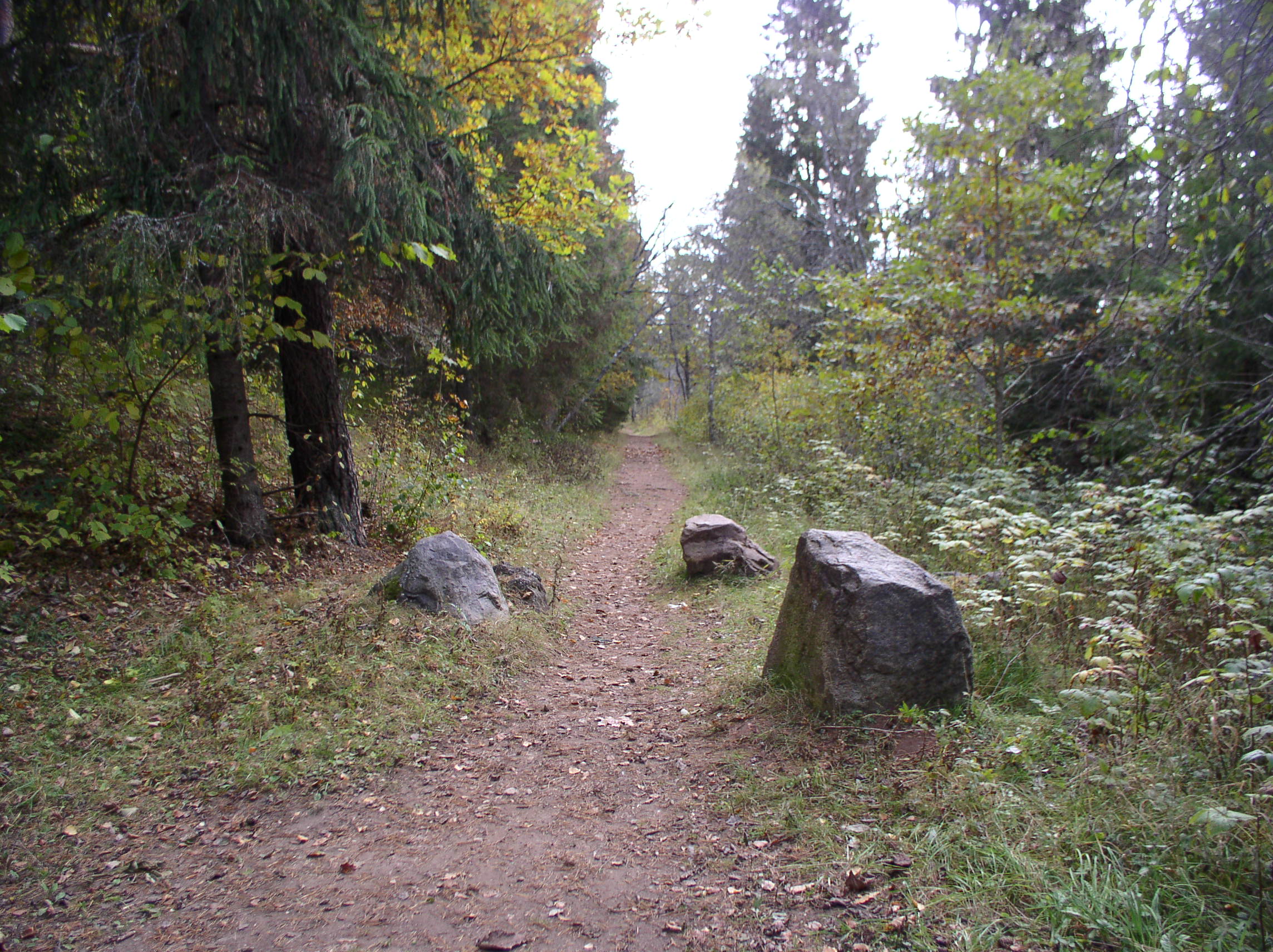
Object type: hiking trail
Location info
Location : Rapla County, Mukri Nature Reserve
Mukri village, Kehtna municipality, Rapla county
Navigation instructions : Drive to Rapla. From Rapla drive by Rapla-Türi road. From Lelle
crossroads turn towards Eidapere and drive 15 km. From Eidapere turn
left after the railroad crossing and drive 1.3 km. The trail is on
your right by the road.
By clicking on the map it will open the map application larger in a new window.
Telephone:
+372 526 1924
E-mail:
info.soomaa@rmk.ee
Object type:
hiking trail
Location info
Location:
Rapla County, Mukri Nature Reserve
Mukri village, Kehtna municipality, Rapla county
Navigation instructions:
Drive to Rapla. From Rapla drive by Rapla-Türi road. From Lelle
crossroads turn towards Eidapere and drive 15 km. From Eidapere turn
left after the railroad crossing and drive 1.3 km. The trail is on
your right by the road.
The observation tower is located on the Mukri nature trail and offers beautiful views of the Mukri bog, bog pools and forests. The trail has three branches, and the shortest way to the observation tower is along the middle branch, which does not have a separate parking lot. It is 670 m from the parking lot through the southeast branch to the observation tower.
Sights
Mukri bog
Amenities
Covered 18 meter high observation tower, information board
Located in Mukri Nature Reserve. Further information can be obtained from the Environmental Board +372 662 5999, info@keskkonnaamet.ee
Contact
Telephone: +372 526 1924
E-mail: info.soomaa@rmk.ee
Object type: observation tower
Location info
Location : Rapla County, Mukri Nature Reserve
Mukri village, Kehtna municipality, Rapla county
Navigation instructions :The observation tower’s location marker on the map shows the location of the study trail's parking lot. Drive to Rapla. From Rapla drive by Rapla-Türi road. From Lelle
crossroads turn towards Eidapere and drive 15 km. From Eidapere turn
left after the railroad crossing and drive 1.3 km. The trail is on
your right by the road.
By clicking on the map it will open the map application larger in a new window.
Telephone:
+372 526 1924
E-mail:
info.soomaa@rmk.ee
Object type:
observation tower
Location info
Location:
Rapla County, Mukri Nature Reserve
Mukri village, Kehtna municipality, Rapla county
Navigation instructions:
The observation tower’s location marker on the map shows the location of the study trail's parking lot. Drive to Rapla. From Rapla drive by Rapla-Türi road. From Lelle
crossroads turn towards Eidapere and drive 15 km. From Eidapere turn
left after the railroad crossing and drive 1.3 km. The trail is on
your right by the road.
Mädara village, Põhja-Pärnumaa municipality, Pärnu County
Navigation instructions : Coming from Pärnu: drive along Vändra and after 9.5 km, just before the Mädara river, turn left. After 900 m, turn right and cross the Mädara River. Drive 3 km along sand dunes and motocross tracks. On the right side of the road there is a parking lot and the Kellissaare campfire site.
Coming from the north (Tallinn and Rakvere): Drive along the Rakvere-Pärnu highway towards Vändra and before Vändra, immediately after the Mädara river, turn right. Drive 3 km along sand dunes and motocross tracks. On the right side of the road there is a parking lot and the Kellissaare campfire site.
By clicking on the map it will open the map application larger in a new window.
Telephone:
+372 526 1924
E-mail:
info.soomaa@rmk.ee
Object type:
campfire site
Location info
Location:
Pärnu County, Sakala Recreation Area
Mädara village, Põhja-Pärnumaa municipality, Pärnu County
Navigation instructions:
Coming from Pärnu: drive along Vändra and after 9.5 km, just before the Mädara river, turn left. After 900 m, turn right and cross the Mädara River. Drive 3 km along sand dunes and motocross tracks. On the right side of the road there is a parking lot and the Kellissaare campfire site.
Coming from the north (Tallinn and Rakvere): Drive along the Rakvere-Pärnu highway towards Vändra and before Vändra, immediately after the Mädara river, turn right. Drive 3 km along sand dunes and motocross tracks. On the right side of the road there is a parking lot and the Kellissaare campfire site.
The observation tower at Lake Parika is accessible by a boardwalk. The site is excellent for a quick excursion for travellers on the Tartu-Viljandi road. A short walk takes visitors to the observation tower at the edge of the Parika bog, where they can safely watch birds in the bog and on the lake.
Location : Viljandi County, Sakala Recreation Area
Viljandi County, Viljandi municipality, 18 km along Viljandi-Põltsamaa road
Navigation instructions : Drive 25 km along Põltsamaa–Viljandi road towards Viljandi. On the right side of the road the sign directs you to the hiking trail. Please park the car by the side of the road.
By clicking on the map it will open the map application larger in a new window.
Telephone:
+372 526 1924
E-mail:
info.soomaa@rmk.ee
Object type:
observation tower
Location info
Location:
Viljandi County, Sakala Recreation Area
Viljandi County, Viljandi municipality, 18 km along Viljandi-Põltsamaa road
Navigation instructions:
Drive 25 km along Põltsamaa–Viljandi road towards Viljandi. On the right side of the road the sign directs you to the hiking trail. Please park the car by the side of the road.
VõimalusedHiking trail/Hiking OptionsCampingFireplaceMaintenance during summerParking
Rapla County, Sakala Recreation Area
Tillniidu campfire site is located in the farmyard of the former Tillniidu forest keeper’s place. The ruins of the farmhouse are still there. There is a fire pond on the yard, where also hikers may take non-drinking water. The campfire site is located by RMK Oandu-Ikla Hiking Route.
Rapla County, Türi municipality, near Vallastu village.
Navigation instructions : If coming from Tallinn:
Drive to Rapla. Head towards Türi from Rapla, drive to Lelle and at the Lelle
road junction turn right towards Eidapere. Drive to Lokuta and turn left there
towards Koogiste. Drive 2.3
km and turn left towards Vallastu. Drive 1.6 km and arrive at
Tillniidu campfire site on your right.
If coming from the north-west, south-east or south-west:
Drive to Türi. Head towards Rapla from Türi, drive to Lelle and at the Lelle
road junction turn left towards Eidapere. Drive to Lokuta and turn left there
towards Koogiste. Drive 2.3
km and turn left towards Vallastu. Drive 1.6 km and arrive at
Tillniidu campfire site on your right.
By clicking on the map it will open the map application larger in a new window.
Telephone:
+372 526 1924
E-mail:
info.soomaa@rmk.ee
Object type:
campfire site
Location info
Location:
Rapla County, Sakala Recreation Area
Rapla County, Türi municipality, near Vallastu village.
Navigation instructions:
If coming from Tallinn:
Drive to Rapla. Head towards Türi from Rapla, drive to Lelle and at the Lelle
road junction turn right towards Eidapere. Drive to Lokuta and turn left there
towards Koogiste. Drive 2.3
km and turn left towards Vallastu. Drive 1.6 km and arrive at
Tillniidu campfire site on your right.
If coming from the north-west, south-east or south-west:
Drive to Türi. Head towards Rapla from Türi, drive to Lelle and at the Lelle
road junction turn left towards Eidapere. Drive to Lokuta and turn left there
towards Koogiste. Drive 2.3
km and turn left towards Vallastu. Drive 1.6 km and arrive at
Tillniidu campfire site on your right.
RMK Hiking Route Oandu-Aegviidu-Ikla / Hirvelaane – Kellissaare (70 km)
VõimalusedHiking trail/Hiking OptionsCampingFireplaceMaintenance during summerParking
Rapla County, Sakala Recreation Area
On the section of the Hiking Route between Tillniidu and Mukri, at the 189 km post, there is a main ditch, which is difficult to cross due to flood. The section of the Hiking Route that goes through Rapla County could be described as a high-potential area, where there are only few points of interest at the moment, but which is still waiting to be discovered.
Sights
The attractions include Loosalu bog, Paluküla Reevimägi, Mukri bog.
Camping
At campsites and campfire sites along the hiking route.
Amenities
Official campsites on the Hiking Route in Rapla County, and the distances between them:
Hirvelaane campfire site - Loosalu campfire site 18 km
Loosalu campfire site -Tillniidu campfire site 22 km
Tillniidu campfire site - Mukri campfire site 13 km
Mukri campfire site- Kellisaare campfire site17 km
Parking
If you start the slightly longer journey from Rapla County, the best starting point is Lelle. There you will definitely find a place to park the car, and also rail and bus connection is available.
The Hiking Route also runs through several nature reserves in Rapla County, and it is recommended to be informed of the nature conservation rules of the reserves. Along the entire Hiking Route one should not forget that camping and making campfire is allowed only in designated places.
Contact
Telephone: +372 526 1924
E-mail: info.soomaa@rmk.ee
Object type: hiking route
Location info
Location : Rapla County, Sakala Recreation Area
Seventy kilometres ofthe Hiking Route in Rapla County, runs mainly on forest tracks, village roadsand asphalt roads. Real hiking can be practiced only on the existingLoosalu-Paluküla and Mukri nature trails and on the short distance betweenKoogiste and Mukri. Larger villages/towns along the trail or in its vicinityare Vana-Kaiu, Paluküla and Lelle.
Telephone:
+372 526 1924
E-mail:
info.soomaa@rmk.ee
Object type:
hiking route
Location info
Location:
Rapla County, Sakala Recreation Area
Seventy kilometres ofthe Hiking Route in Rapla County, runs mainly on forest tracks, village roadsand asphalt roads. Real hiking can be practiced only on the existingLoosalu-Paluküla and Mukri nature trails and on the short distance betweenKoogiste and Mukri. Larger villages/towns along the trail or in its vicinityare Vana-Kaiu, Paluküla and Lelle.
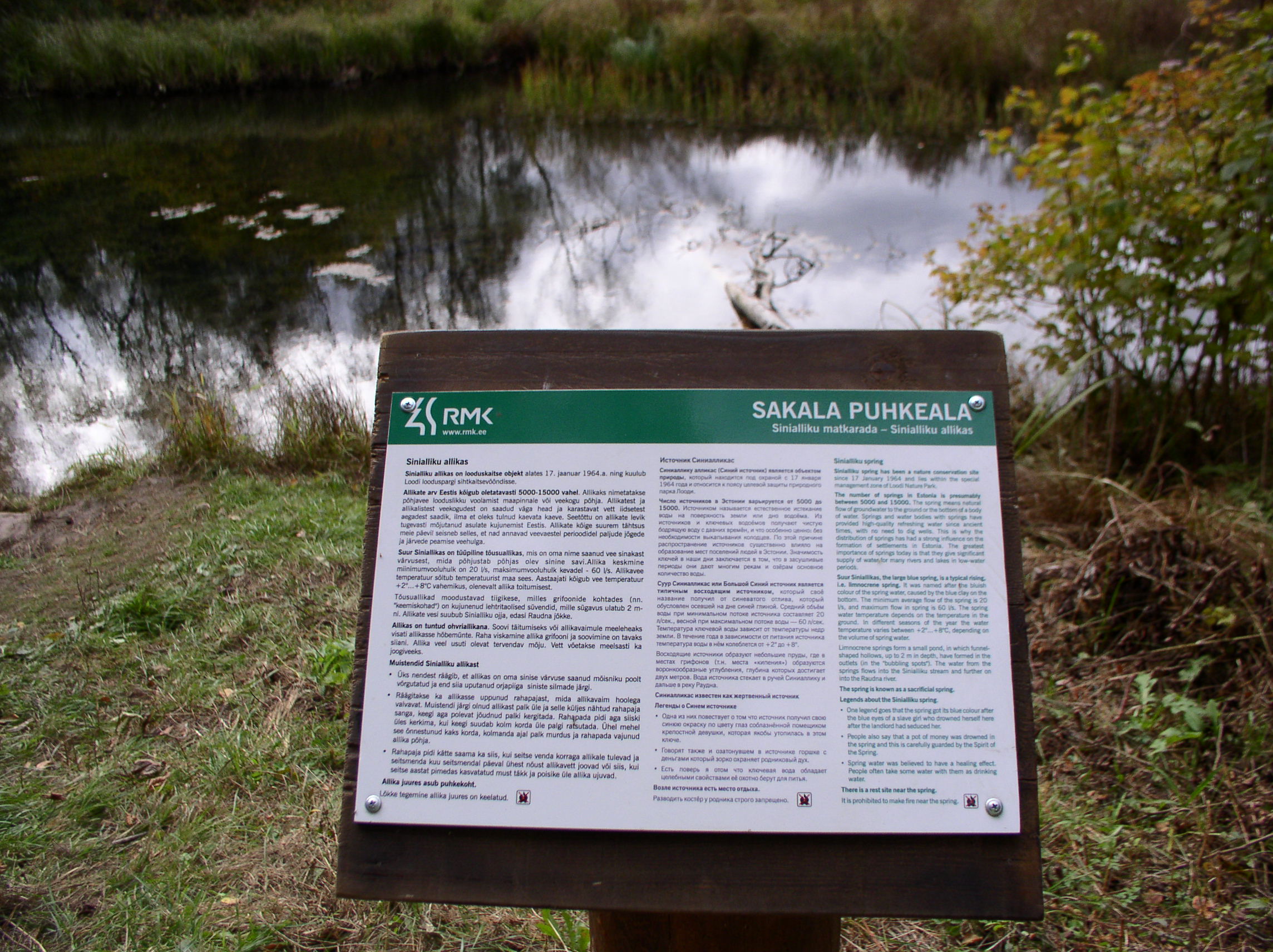
Sinialliku hiking trail goes along the shore of the beautiful Lake Sinialliku and leads to the enigmatic springs. Hikers can also ascend to the ancient hill fort. You can start the trail either near the former Sinialliku railway station or at Karksi-Nuia–Viljandi road. Hikers can take a longer break at the campfire site, which also offers a safe camping opportunity.
The hiking trail is located in Loodi Nature Park. Further information can be obtained from the Environmental Board +372 662 5999, info@keskkonnaamet.ee
Contact
Telephone: +372 526 1924
E-mail: info.soomaa@rmk.ee
Object type: hiking trail
Location info
Location : Viljandi County, Sakala Recreation Area
Sinialliku village, Viljandi municipality, Viljandi county
Navigation instructions : Drive along Imavere–Viljandi road, and 4.5 km from Viljandi towards Karksi-Nuia. At the Sinialliku sign turn right and drive 0.8 km to the parking area. Follow the signs along the hiking trail to the springs.
By clicking on the map it will open the map application larger in a new window.
Telephone:
+372 526 1924
E-mail:
info.soomaa@rmk.ee
Object type:
hiking trail
Location info
Location:
Viljandi County, Sakala Recreation Area
Sinialliku village, Viljandi municipality, Viljandi county
Navigation instructions:
Drive along Imavere–Viljandi road, and 4.5 km from Viljandi towards Karksi-Nuia. At the Sinialliku sign turn right and drive 0.8 km to the parking area. Follow the signs along the hiking trail to the springs.