Where to go
Värska rental hut II

Värska rental hut II


Võimalused

Hiking trail/Hiking Options
Rental hut/Nature house
Fireplace
Fireplace
Maintenance during summer
Parkimine
Parkimine
Võru County, Räpina-Värska Recreation Area

Värska Rental Hut II is located on the shore of Lake Õrsava. You can enjoy your morning coffee on the hut’s large terrace. Next to the house there is a campfire site with grill rests, table-benches, and a dry toilet. Here you can swim, play ball, fish, hike on the Õrsava Lake Hiking Trail or take you bike and head for the Laskevälja cycling trail. The surrounding patch of forest contains both berries and mushrooms in summer and autumn. The campfire site is primarily meant for the rental hut users!

Booking terms and conditions

Booking terms and conditions for RMK nature houses and rental huts

Estonian State Forests Management Centre (RMK) shall abide by the following terms and conditions for booking and cancelling the booking of nature houses and rental huts:

  • Pre-sales invoice shall be paid by the due date as specified on the invoice.
  • The customer shall have to cancel the booking, if he/she has decided not to use the nature house or rental hut.

In case the customer has not paid the invoice by the due date, RMK is entitled to cancel the booking.

RMK nature houses and rental huts can be booked online www.bouk.io or by e-mail at puhkus@rmk.ee

Persons under the age of 18 are allowed to book and use the nature house and rental hut only together with an adult..

For each nature house and rental hut, the number of customers who can use the facility at the same time is limited and that number is specified in the description of the nature house and rental hut on RMK homepage. The number of users does not include children aged 1-3.

An advance booking can be made for a nature house and rental hut for up to seven days.
Within seven days from advance booking the booking has to be confirmed in writing, otherwise the booking will be void. If the customer wants to use extra services in addition to renting the nature house (nature programme, hiking, transport etc.), RMK shall make a respective offer.

After booking or confirming the advance booking, the customer shall receive a pre-sales invoice for the whole sum. If the booking is made earlier than 21 days before using the service, the customer shall receive a pre-sales invoice for the whole sum, which must be paid within 14 days after booking. If the booking is made later than 14 days before using the service, the customer shall receive a pre-sales invoice for the whole sum, which must be paid immediately.

The pre-sales invoice shall be paid by the due date shown on the invoice. After the payment of the invoice has been received, RMK shall issue a regular invoice to the customer, if requested, to confirm the booking.

With the pre-sales invoice the customer shall receive the contact information of the caretaker of the nature house/rental hut and information how the customer receives the keys to the nature house/rental hut. The customer him/herself shall agree with the caretaker about the time of arriving and leaving.
RMK reserves the right to change the quoted prices.

The customer can cancel a reservation for a nature or forest house made online in the BOUK self-service environment.
An email booking of a nature house or rental hut can be cancelled by email to puhkus@rmk.ee

Cancelling date is the date when RMK receives information about cancellation of the booking. If the customer proves that cancellation was sent in good time to be delivered by the intended time, RMK shall accept the cancellation, even if it is delivered later or is not delivered at all.  

If the booking of the rental hut is cancelled 7 days or more before using the service, the customer shall be refunded the advance payment less the service fee (2,00 EUR).

If the booking is cancelled later than 6 days but earlier than 73 hours before using the service, the customer shall be refunded 75 percent of the total sum.

If the booking is cancelled later than 72 hours before using the service, no refund shall be made to the customer.

If the booking is cancelled before starting to use the service due to the illness, involvement in an accident or death of the customer or a person close to the customer, the customer is entitled to full refund.
In this case the customer shall have to inform the RMK Nature Management Department immediately of cancelling the booking. Within two weeks at the latest certification (from the doctor, police etc) on the cause of cancelling the booking needs to be provided and sent to:
RMK Visitor Management Department, Sagadi Village, Haljala Municipality, 45403 Lääne-Viru County. If the booking is cancelled for the above-mentioned reasons during the time of using the service, no refund shall be made to the customer.

If the customer wants to change the time or place of using the service, it will be regarded as cancellation of the earlier booking and making a new booking.

RMK shall be entitled to cancel a booking due to force majeure (natural disaster, high risk of forest fire, strike etc.), in which case RMK shall inform the customer as soon as possible. In this case the customer is entitled to full refund of the payment. The customer shall not be compensated for possible additional costs incurred.

The customer shall return the key to the rental hut according to the instructions received.

The customer (person who has made reservation) ensures that all people who are using the house follow the house rules that are introduced while house was handed over for their use. The customer (person who has made reservation) ensures that all visitors follow the generally accepted quiet time (23.00 to 6.00) of RMK´s nature houses and rental huts.

6.1. Use of the rental hut
The estimated time of arrival of customers at the rental hut is 16.00, the estimated time of leaving is 12.00.
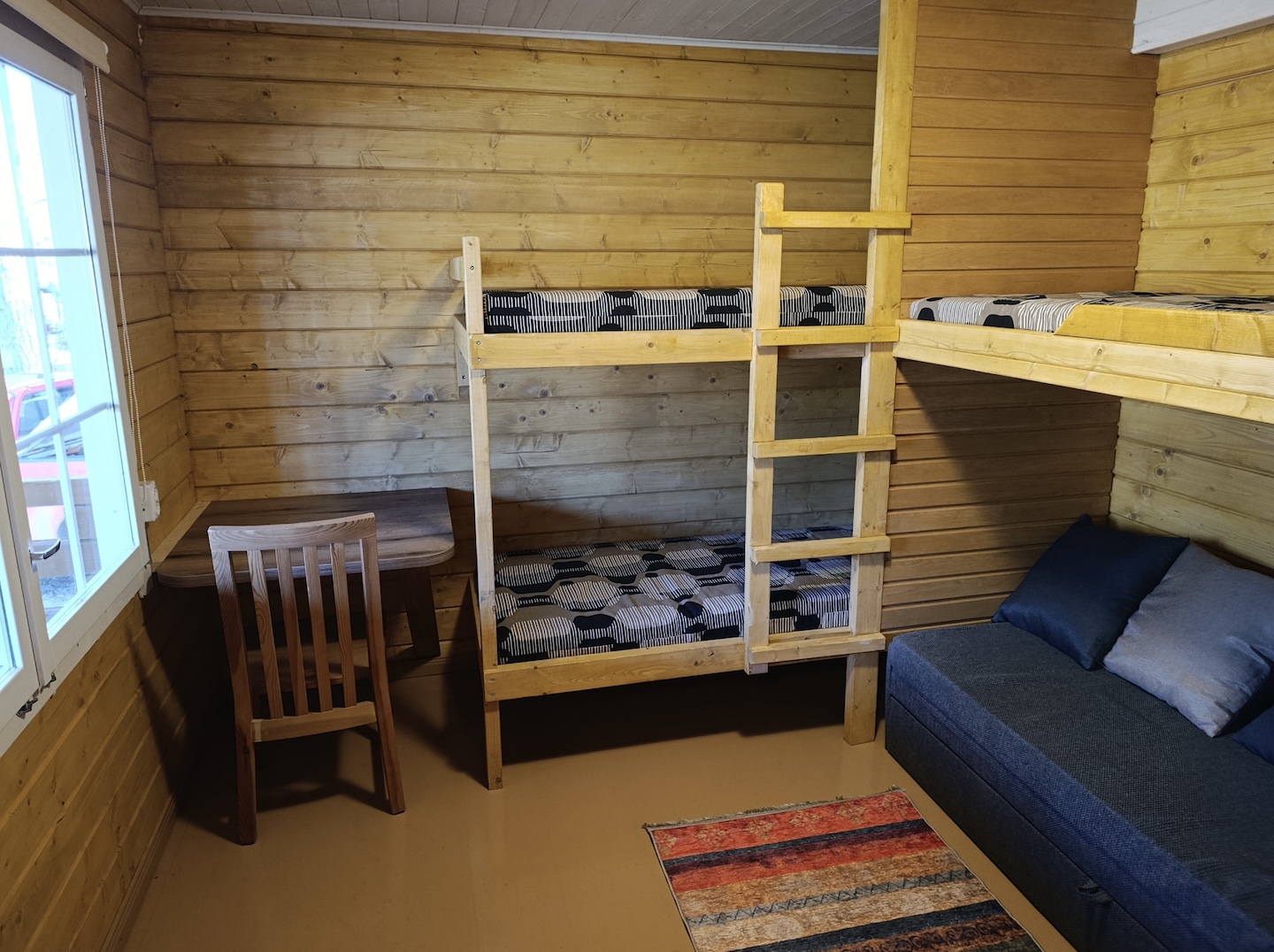
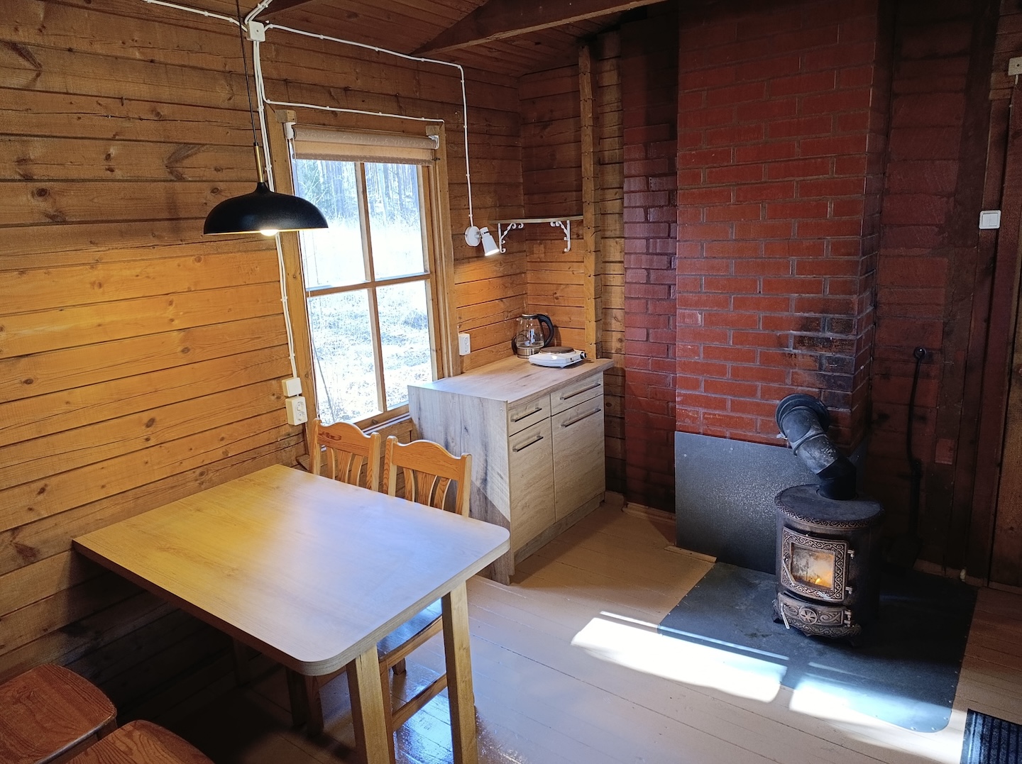
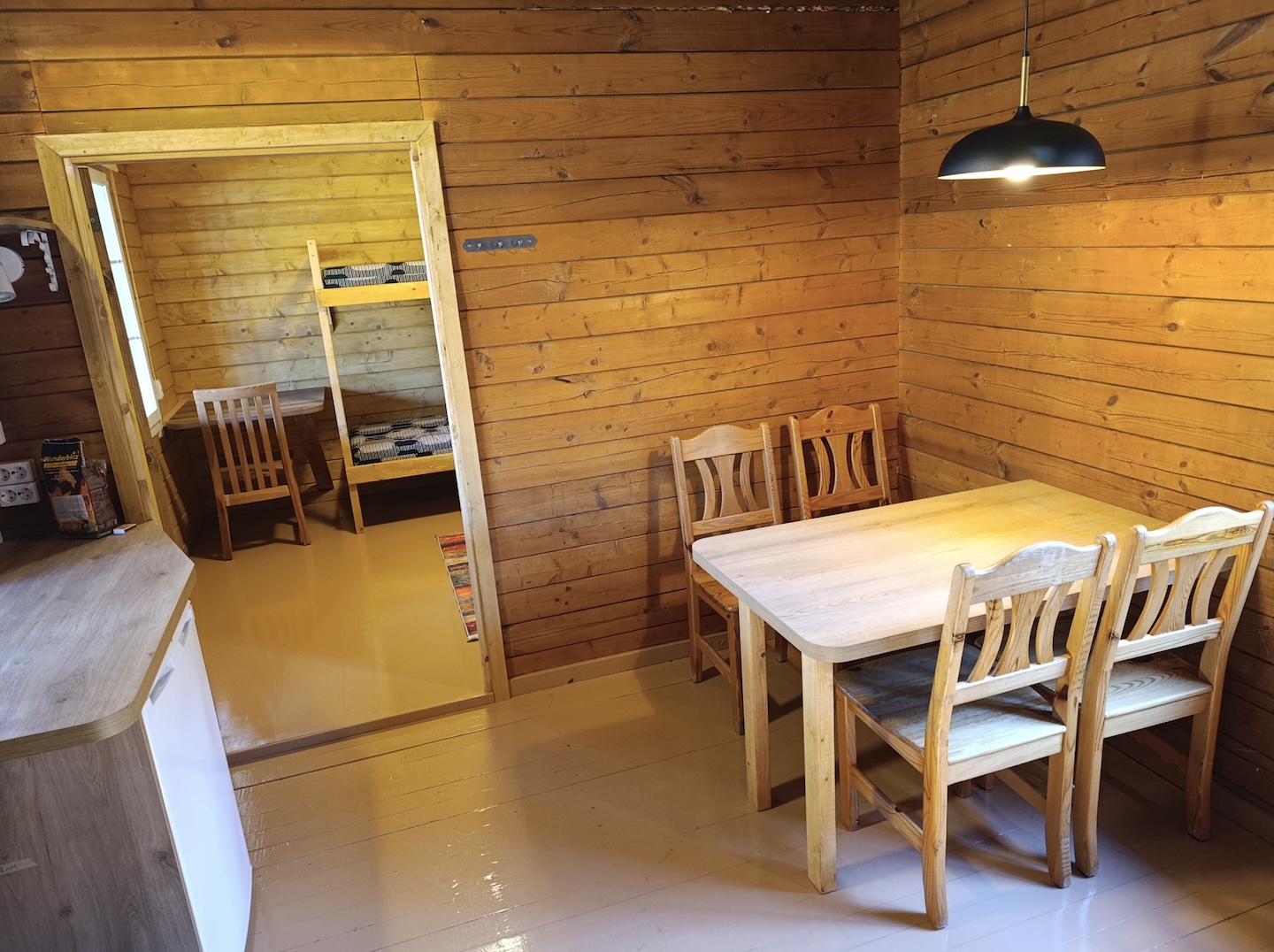
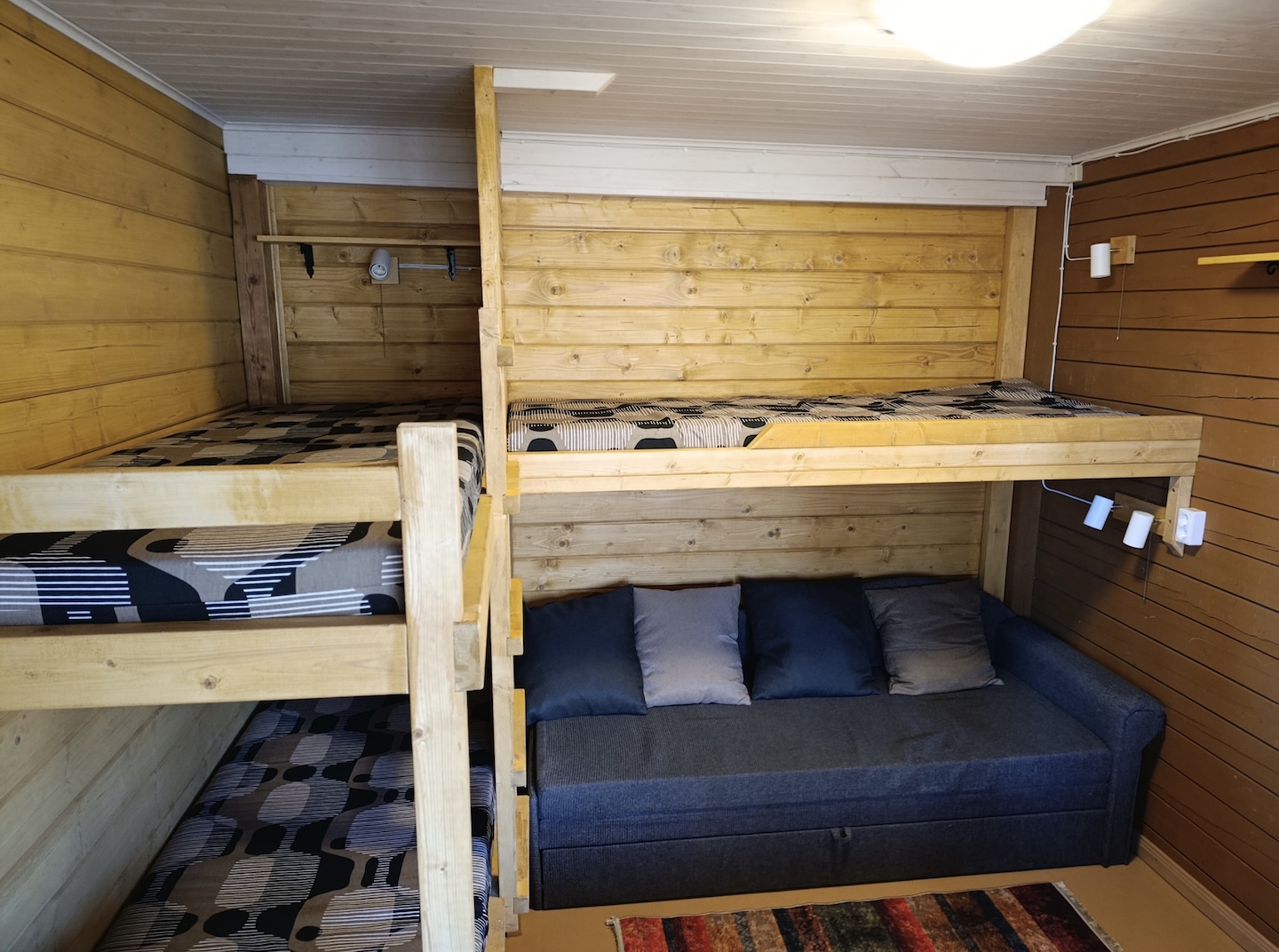
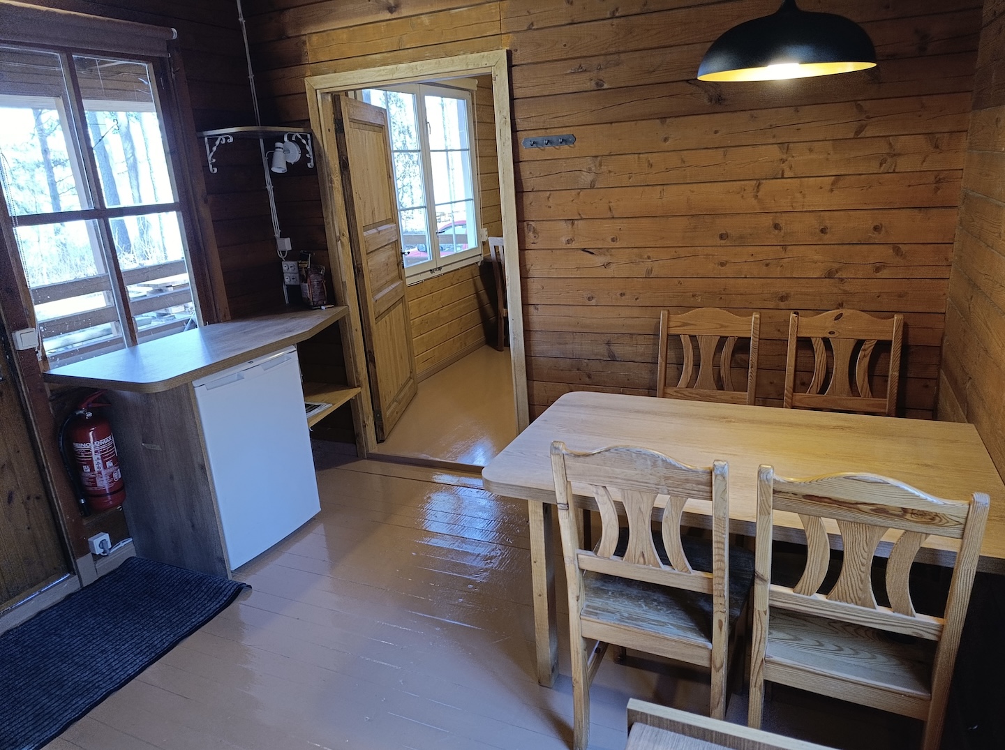
Rental huts have spartan furnishing only – a bench, a table and a fireplace. Customers have to bring sleeping gear and other necessary items with them. The user of a rental hut shall ensure that the hut and the furnishings of the hut remain in good order when he/she leaves.

7.1. The customer shall be liable to compensate to RMK for damage caused by negligent use or misuse of the nature house or rental hut..

7.2. At the request of RMK, the customer undertakes to pay a contractual penalty to the extent of double charge for using the rental hut, in case the actual number of users of the rental hut exceeds the permitted number of users established for the rental hut.

7.3. The customer undertakes to pay the contractual penalty in the sum 130,00 EUR at the request of RMK, in case  the actual number of users of the nature house exceeds the permitted number of users established for the nature house.

Any complaints shall be filed to the caretaker of the nature house or rental hut immediately when a problem emerges. If it is impossible to find a satisfying solution to the problem on site, a complaint shall be sent in writing to RMK Visitor Management Department, Sagadi Village, Haljala Municipality, 45403 Lääne-Viru County within one week after using the service. RMK shall handle the complaint within one month.

All disputes shall be settled by negotiation. If agreement cannot be reached by negotiations, the dispute shall be settled pursuant to the procedure prescribed by law.

RMK shall not be liable to compensate damages or expenses resulting from natural conditions, such as e.g. mosquitoes, mice or unexpected weather changes.

RMK processes personal data in compliance with the European Union data protection regulation and accordingly to the valid Terms and Conditions of Data Protection in RMK.

Sights

A good spot for a lakeside summer family holiday where you can go swimming in the lake or walking in the forest, learn about Mustoja Landscape Protection Area with its largest and most prominent kames and eolian landforms with sand plains, Õrsava hiking trail and Seto Farm Museum.

Hiking options

On the Õrsava hiking trail.

Amenities
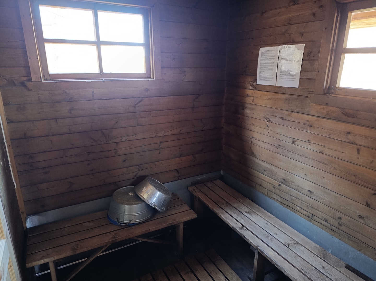
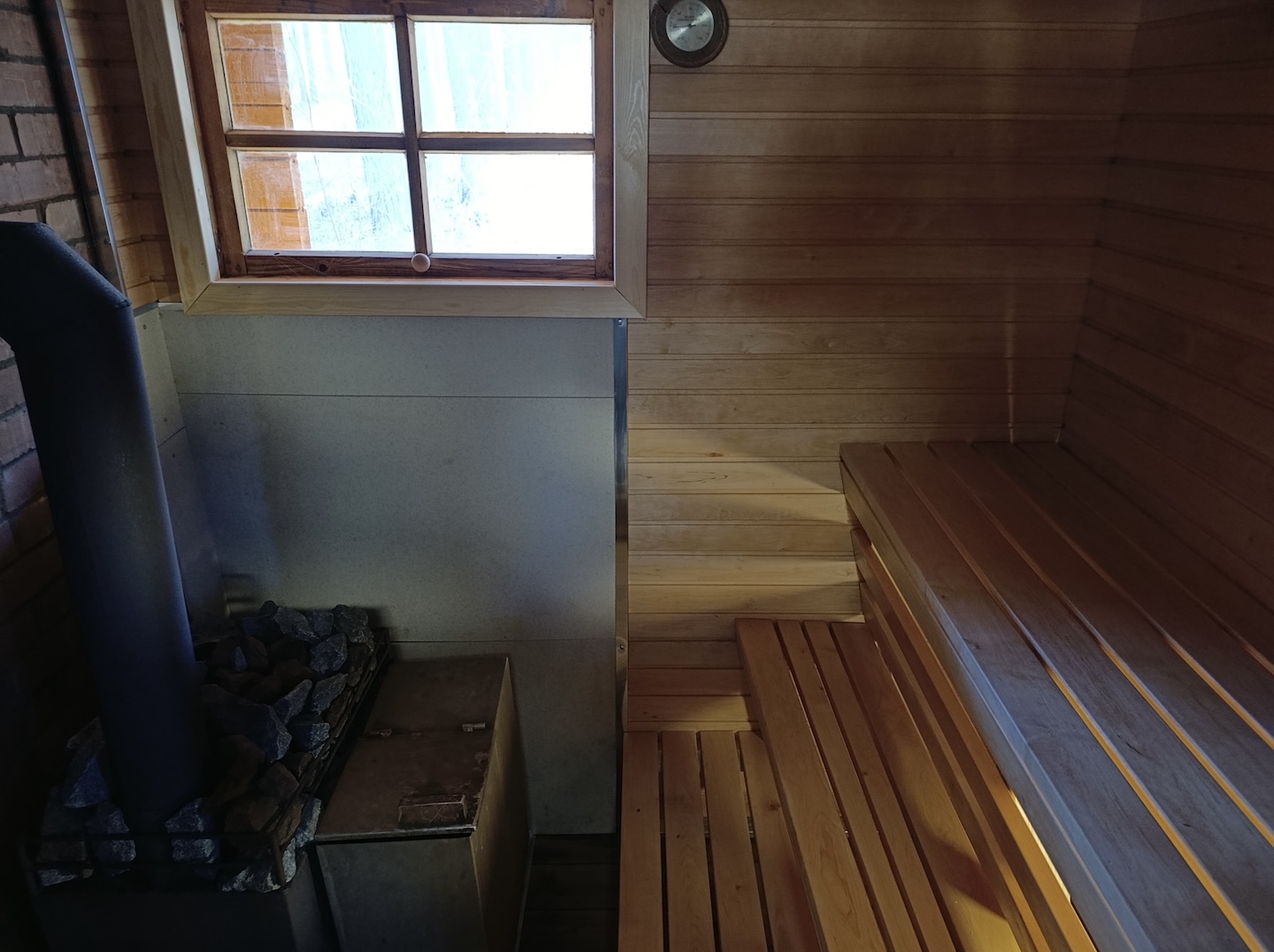
  • Furnished with a table, benches, refrigerators, a fireplace, a sauna, but no kitchen.
  • There are campfire sites, a ball court, boat deck and dry toilets nearby.
  • Guests must bring their own bedding. Drinking water from a natural freshwater spring.
  • Firewood in shed 100 m from the hut. Water for the sauna must be brought from the lake.
Parking

The rental hut is not accessible by car, parking in the parking area for 5 cars about 100 m from the hut.

Additional information
  • Advance booking is required!
  • Clean the rooms before leaving the rental hut.
  • The object is equipped with firewood.
  • Before going on a nature walk please read the rules of conduct
Restrictions

Persons under the age of 18 can book and use the rental hut only when accompanied by an adult. The hut is not available for use during winter.

Contact

Telephone: View availability in the calendar and book online at www.bouk.io by clicking on the book button:
Book button image

E-mail: puhkus@rmk.ee

Object type: rental hut

Hind: 55 €/day
Pet 5 €/day

Location info

Location : Võru County, Räpina-Värska Recreation Area

Lobotka village, Setomaa municipality, Võru County

Navigation instructions : Drive on Tartu–Värska road and before arriving at Värska, turn right (sign to Treski). Drive about 10 m and turn left. Follow the arrow signs to the Värska and Luige rental huts.

Coordinates:

Long-Lat WGS 84
Latitude: 57.947251
Longitude: 27.634193
L-EST 97x: 715113
L-EST 97y: 6428688

By clicking on the map it will open the map application larger in a new window.

Telephone:
View availability in the calendar and book online at www.bouk.io by clicking on the book button:
Book button image
E-mail:
puhkus@rmk.ee
Object type:
rental hut
Price:
55 €/day
Pet 5 €/day
Location info
Location:
Võru County, Räpina-Värska Recreation Area
Lobotka village, Setomaa municipality, Võru County
Navigation instructions:
Drive on Tartu–Värska road and before arriving at Värska, turn right (sign to Treski). Drive about 10 m and turn left. Follow the arrow signs to the Värska and Luige rental huts.
Coordinates:

Long-Lat WGS 84
Latitude: 57.947251
Longitude: 27.634193
L-EST 97x: 715113
L-EST 97y: 6428688

Where to go
Ilumetsa rest stop (Meteorite Craters)

Ilumetsa rest stop (Meteorite Craters)


Võimalused

Rest stop
Rest stop
Year-round maintenance
Wheelchair Accessibility
Parkimine
Parkimine
Võru County, Räpina-Värska Recreation Area

Ilumetsa recreation site is situated near meteorite craters. There is a tourist information cabin, boardwalk, parking area and dry toilet at the recreation site. Camping with tents is not allowed. The site leads to a fascinating walk to the largest meteorite crater here, called Põrguhaud or “Grave of hell”. Wheelchair accessibility.

Sights

Ilumetsa meteorite craters

Amenities

Information cabin, boardwalk, parking area and dry toilet.

Parking

Parking for 4 to 5 cars.

Additional information

Before going on a nature walk please read the rules of conduct

Contact

Telephone: +372 676 7122

E-mail: info.kiidjarve@rmk.ee

Object type: rest stop

Location info

Location : Võru County, Räpina-Värska Recreation Area

Võru municipality, Võru County

Navigation instructions : Drive from Põlva towards Värska to the Ilumetsa railway station. Turn right before the railway crossing (the sign “Ilumetsa meteoriidikraatrid”), drive 0.5 km and arrive at the site.

Coordinates:

Long-Lat WGS 84
Latitude: 57.957127
Longitude: 27.406476
L-EST 97x: 701590
L-EST 97y: 6429079

By clicking on the map it will open the map application larger in a new window.

Telephone:
+372 676 7122
E-mail:
info.kiidjarve@rmk.ee
Object type:
rest stop
Location info
Location:
Võru County, Räpina-Värska Recreation Area
Võru municipality, Võru County
Navigation instructions:
Drive from Põlva towards Värska to the Ilumetsa railway station. Turn right before the railway crossing (the sign “Ilumetsa meteoriidikraatrid”), drive 0.5 km and arrive at the site.
Coordinates:

Long-Lat WGS 84
Latitude: 57.957127
Longitude: 27.406476
L-EST 97x: 701590
L-EST 97y: 6429079

Where to go
Liipsaare observation tower

Liipsaare observation tower


Võimalused

Hiking trail/Hiking Options
Observation tower
Observation tower
Covered fireplace
Covered fireplace
Maintenance during summer
Parkimine
Parkimine
Põlva County, Räpina-Värska Recreation Area

From Liipsaare observation tower hikers get a wonderful view of the Meenikunno bog landscape.

Sights

A view of the Meenikunno bog

Hiking options

Tower is on the Meenikunno hiking trail.

Amenities

11 m high observation tower

Parking

Parking in Liipsaare parking area about 300 m from the tower.

Additional information

Before going on a nature walk please read the rules of conduct

Restrictions

The observation tower is situated in the Meenikunno Nature Reserve. Further information can be obtained from the Environmental Board +372 662 5999, info@keskkonnaamet.ee

Contact

Telephone: +372 676 7122

E-mail: info.kiidjarve@rmk.ee

Object type: observation tower

Location info

Location : Põlva County, Räpina-Värska Recreation Area

Räpina municipality, Põlva County

Navigation instructions : Drive 15 km from Räpina towards Võru, turn left towards Värska. Drive 3.8 km and turn right towards Meenikunno Nature Reserve. Drive 5.5 km and turn right. Drive another 1.5 km and follow the sign “Liipsaare” in the parking area to the right to the observation tower.

Coordinates:

Long-Lat WGS 84
Latitude: 57.931946
Longitude: 27.310006
L-EST 97x: 696025
L-EST 97y: 6425993

By clicking on the map it will open the map application larger in a new window.

Telephone:
+372 676 7122
E-mail:
info.kiidjarve@rmk.ee
Object type:
observation tower
Location info
Location:
Põlva County, Räpina-Värska Recreation Area
Räpina municipality, Põlva County
Navigation instructions:
Drive 15 km from Räpina towards Võru, turn left towards Värska. Drive 3.8 km and turn right towards Meenikunno Nature Reserve. Drive 5.5 km and turn right. Drive another 1.5 km and follow the sign “Liipsaare” in the parking area to the right to the observation tower.
Coordinates:

Long-Lat WGS 84
Latitude: 57.931946
Longitude: 27.310006
L-EST 97x: 696025
L-EST 97y: 6425993

Where to go
RMK Peraküla-Aegviidu-Ähijärve hiking route / Kiidjärve-Piusa (121 km)

RMK Peraküla-Aegviidu-Ähijärve hiking route / Kiidjärve-Piusa (121 km)


Võimalused

Hiking trail/Hiking Options
Camping
Camping
Fireplace
Fireplace
Maintenance during summer
Parkimine
Parkimine
Põlva County, Räpina-Värska Recreation Area

The longest section of Peraküla-Aegviidu-Ähijärve hiking route takes the hiker through the varied landscapes of Estonia. From Kiidjärve Visitor Centre, the trail goes along the amazing bank of the Ahja river towards the Taevaskoja outcrops, where one should step off the trail to study them. From Taevaskoja, the route proceeds over the field to Otteni rental hut and campfire site. Next, it passes the places where the film "The Last Relic" was shot and goes along forest roads towards Põlva. After leaving the lands of Mammaste Health and Sports Centre and the forest, the trail takes the hiker to the town of Põlva, where it is possible to replenish your supplies. Next, continuing along a cycling and pedestrian track, the trail arrives at the Rosma hill fort and the forest hiking trail. After Peri campfire site, the route continues on an asphalt road through the Peri village. Thereafter the trail follows a gravel road towards Saarjärve Holiday Centre. From Saarjärve, the trail continues along wonderful forest tracks to Koolma village, where the Võhandu river is crossed. After passing Leevi and Paidra campfire sites and through Lihtenstein village, it takes hikers to Meenikunno Landscape Protection Area. Walkers and cyclists go through the landscape protection area along different routes. From Meenikunno, the hikers go towards Värska, where it is possible to restock supplies and visit the Seto Farm Museum and the Tsäimaja cafe. Next, the route goes along the Laskevälja cycling trail through the varied Mustoja Landscape Protection Area. In Kolossova village we recommend visiting Vana Jüri Seebikoda – the artisan soap shop. From Matsuri hikers should go on the old railroad bed, which takes them towards the Piusa Caves.

Sights

Väike and Suur Taevaskoda (outcrops), Ahja river, scenes of the film "The Last Relic", Võhandu river, Meenikunno bog, Mustoja Landscape Protection Area, Piusa caves.

Camping

Tent camping is possible at all the rest stops on this section, except for Liipsaare forest hut.

Amenities

The trail is marked with signs and colour markings at turns, as well as with kilometer markers. The rest stops on the trail and distances:

  • Kiidjärve Visitor centre-Sõnajala campfire site 0,5 km
  • Sõnajala campfire site- Otteni campfire site 8 km
  • Otteni campfire site-Peri campfire site 12 km
  • Peri campfire site-Leevi campfire site 20 km
  • Leevi campfire site-Liipsaare forest hut 14 km
  • Liipsaare forest hut-Mustjärve campfire site 4,5 km
  • Mustjärve campfire sit-Valgjärve campfire site 1,5 km
  • Valgjärve campfire site-Rebasmäe forest hut 4,5 km
  • Rebasmäe forest hut-Värska campfire site 20 km
  • Värska campfire site-Poogandi campfire site 16 km
  • Poogandi campfire site-Lõunalaagri campfire site 9 km
  • Lõunalaagri campfire site-Piusa campfire site 15 km
Water

In his section of the hiking route, non-potable water is not available near Liipsaare forest hut, and Lõunalaagri and Piusa campfire sites. Near Peri campfire site there is a small stream, which can be waterless in summer.

Parking

For long-term parking it is convenient to use the parking area at Kiidjärve Visitor Centre. In addition, parking is available in most campfire sites on this section of the hiking route.

Additional information

Before going on a nature walk please read the rules of conduct

Restrictions

This section of the hiking route is in the territory of several protected areas, so visitors should have general knowledge of their protection rules. On the hiking route one should not forget that camping and making a fire is allowed only at places designated for those purposes.

The hiking route goes through the Ahja river valley, Lake Kuulmajärv, Meenikunno and Mustoja Landscape Protection Areas and the Piusa Caves Nature Reserve. Further information about restrictions can be obtained from the Environmental Board info@keskkonnaamet.ee, +372 662 5999.

Contact

Telephone: +372 676 7122

E-mail: info.kiidjarve@rmk.ee

Object type: hiking route

Location info

Location : Põlva County, Räpina-Värska Recreation Area

The hiking trail is in Põlva, Räpina, Setomaa municipalities in Põlva County and in Võru municipality in Võru County.

Navigation instructions : To get to Kiidjärve Visitor Centre, drive from Tartu towards Põlva along Põlva-Reola Road. 10 km before Põlva turn left towards Kiidjärve at Koorvere intersection. Drive 4 km along Akste-Häätaru Road (road no. 18138). 1 km after Kiidjärve park bus stop there is a large parking area on the left. This is the parking area of RMK Kiidjärve Visitor Centre.

Telephone:
+372 676 7122
E-mail:
info.kiidjarve@rmk.ee
Object type:
hiking route
Location info
Location:
Põlva County, Räpina-Värska Recreation Area
The hiking trail is in Põlva, Räpina, Setomaa municipalities in Põlva County and in Võru municipality in Võru County.
Navigation instructions:
To get to Kiidjärve Visitor Centre, drive from Tartu towards Põlva along Põlva-Reola Road. 10 km before Põlva turn left towards Kiidjärve at Koorvere intersection. Drive 4 km along Akste-Häätaru Road (road no. 18138). 1 km after Kiidjärve park bus stop there is a large parking area on the left. This is the parking area of RMK Kiidjärve Visitor Centre.
Coordinates:

Where to go
Laskevälja cycling trail (43 km)

Laskevälja cycling trail (43 km)


Võimalused

Cycling trail
Cycling trail
Camping
Camping
Fireplace
Fireplace
Covered fireplace
Covered fireplace
Year-round maintenance
Võru County, Räpina-Värska Recreation Area

Laskevälja cycling trail introduces the military history and cultural heritage of the Värska area. The trail goes along the former military shooting area used before WWII. On the 43 km trail, it is possible to experience the charm and the challenge of the largest and most elevated kame area in south-eastern Estonia – the Mustoja kame area.

Sights

Mustoja kame area, varied massive forests.

Camping

Tents can be used on the Värska, Lõunalaagri and Poogandi campfire sites.

Amenities

43 km circular trail, with directing signs. There are 12 information boards on the trail, introducing the military history and the objects of cultural heritage in the area.

Parking

Parking area for 10 cars at Värska or Lõunalaagri campfire sites.

Additional information
  • The first part of the trail from Värska to Lõunalaagri campfire site is quite easy, while the second part back to Värska is more hilly and definitely requires a mountain bike.
  • NB! Please have your ID document with you. This is a border zone.
  • Before going on a nature walk please read the rules of conduct
Restrictions

The trail passes the Mustoja Landscape Protection Area. Further information can be obtained from the Environmental Board +372 662 5999, info@keskkonnaamet.ee

Contact

Telephone: +372 676 7122

E-mail: info.kiidjarve@rmk.ee

Object type: cycling trail

Location info

Location : Võru County, Räpina-Värska Recreation Area

Setomaa municipality, Võru County

Navigation instructions : Before the sign of entry into Värska, turn right towards Treski and then turn left (follow the signs "Värska metsamaja", "Luige metsamaja"). Drive about 1.8 km and turn left (follow the sign "Värska lõkkekoht"). Go on for about 100 m and you'll get to the campfire site, where there is also information about the cycling trail.

Coordinates:

Long-Lat WGS 84
Latitude: 57.946564
Longitude: 27.634510
L-EST 97x: 715136
L-EST 97y: 6428613

By clicking on the map it will open the map application larger in a new window.

Telephone:
+372 676 7122
E-mail:
info.kiidjarve@rmk.ee
Object type:
cycling trail
Location info
Location:
Võru County, Räpina-Värska Recreation Area
Setomaa municipality, Võru County
Navigation instructions:
Before the sign of entry into Värska, turn right towards Treski and then turn left (follow the signs "Värska metsamaja", "Luige metsamaja"). Drive about 1.8 km and turn left (follow the sign "Värska lõkkekoht"). Go on for about 100 m and you'll get to the campfire site, where there is also information about the cycling trail.
Coordinates:

Long-Lat WGS 84
Latitude: 57.946564
Longitude: 27.634510
L-EST 97x: 715136
L-EST 97y: 6428613

Where to go
Lõunalaagri campfire site

Lõunalaagri campfire site


Võimalused

Hiking trail/Hiking Options
Camping
Camping
Covered fireplace
Covered fireplace
Year-round maintenance
Võru County, Räpina-Värska Recreation Area

A nice campfire site on the Lõunalaagri hiking trail at an artificial lake. Nearby forests are rich in berries and mushrooms.

Hiking options

The campfire site is on the Lõunalaagri hiking trail, nearby Laskevälja cycling trail and RMK Peraküla-Aegviidu-Ähijärve Hiking Route.

Camping

Maximum number of tents (for 4) allowed is 4.

Amenities

Fire ring with grill, firewood shelter, benches, dry toilet, table and benches with shelter.

Parking

Parking area for up to 30 cars by Matsuri-Sesniki Road.

Additional information

Before going on a nature walk please read the rules of conduct

Contact

Telephone: +372 676 7122

E-mail: info.kiidjarve@rmk.ee

Object type: campfire site

Location info

Location : Võru County, Räpina-Värska Recreation Area

Voropi village, Setomaa municipality, Võru County

Navigation instructions : Take the Tartu-Koidula Road up to Matsuri, then turn left (follow the sign "Lõunalaagri matkarada"). Drive about 4.2 km and you are there.

Coordinates:

Long-Lat WGS 84
Latitude: 57.846575
Longitude: 27.639781
L-EST 97x: 716051
L-EST 97y: 6417509

By clicking on the map it will open the map application larger in a new window.

Telephone:
+372 676 7122
E-mail:
info.kiidjarve@rmk.ee
Object type:
campfire site
Location info
Location:
Võru County, Räpina-Värska Recreation Area
Voropi village, Setomaa municipality, Võru County
Navigation instructions:
Take the Tartu-Koidula Road up to Matsuri, then turn left (follow the sign "Lõunalaagri matkarada"). Drive about 4.2 km and you are there.
Coordinates:

Long-Lat WGS 84
Latitude: 57.846575
Longitude: 27.639781
L-EST 97x: 716051
L-EST 97y: 6417509

Where to go
Nohipalo study trail (3 km)

Nohipalo study trail (3 km)


Võimalused

Study trail
Study trail
Circular trail
Circular trail
Year-round maintenance
Parkimine
Parkimine
Põlva County, Räpina-Värska Recreation Area

Nohipalo study trail starts and ends at the Ilumetsa rental hut and is ca 3 km long. There are 16 information boards on the trail, introducing hunting and forestry. The trail takes about 1,5 hours to complete.

Sights

Badger area, pine forests, eskers, heath forests, traces of beaver activity.

Amenities

Information boards and direction signs on the study trail.

Parking

At Ilumetsa rental hut for max 4 cars.

Additional information

Before going on a nature walk please read the rules of conduct

Contact

Telephone: +372 676 7122

E-mail: info.kiidjarve@rmk.ee

Object type: hiking trail

Location info

Location : Põlva County, Räpina-Värska Recreation Area

Nohipalo village, Räpina municipality, Põlva County

Navigation instructions : Drive 15 km from Räpina towards Võru, then turn left towards Värska and drive 3.8 km up to an intersection where a sign "Meenikunno maastikukaitseala" directs to the right. Follow the sign and drive 2.1 km until you get to Nohipalo village, where the sign "Ilumetsa metsamaja" directs to the left. Drive about 200 m to the rental hut.

Coordinates:

Long-Lat WGS 84
Latitude: 57.956754
Longitude: 27.352745
L-EST 97x: 698415
L-EST 97y: 6428878

By clicking on the map it will open the map application larger in a new window.

Telephone:
+372 676 7122
E-mail:
info.kiidjarve@rmk.ee
Object type:
hiking trail
Location info
Location:
Põlva County, Räpina-Värska Recreation Area
Nohipalo village, Räpina municipality, Põlva County
Navigation instructions:
Drive 15 km from Räpina towards Võru, then turn left towards Värska and drive 3.8 km up to an intersection where a sign "Meenikunno maastikukaitseala" directs to the right. Follow the sign and drive 2.1 km until you get to Nohipalo village, where the sign "Ilumetsa metsamaja" directs to the left. Drive about 200 m to the rental hut.
Coordinates:

Long-Lat WGS 84
Latitude: 57.956754
Longitude: 27.352745
L-EST 97x: 698415
L-EST 97y: 6428878

Where to go
Giants of Ootsipalu Valley

Giants of Ootsipalu Valley


Võimalused

Maintenance during summer
Parkimine
Parkimine
Põlva County, Räpina-Värska Recreation Area

Many grand and magnificent trees grow in Ootsipalu valley in Räpina municipality, Põlva County, but two of them are particularly worthy of attention. These are the tallest spruce in Estonia and the tallest pine in Estonia – 48.6 and 46.6 metres tall, respectively.

Sights

The giant trees that stand quite close to one another are more than 200 years old. As of the beginning of the year 2016, the pine-tree is the tallest Scots pine (Pinus sylvestris) in the world. There are more than one hundred different pine species in the world. The Scots pine grows in Europe. In Estonia, the Scots pine is the only natural pine species and also the most frequently found tree in our forests. According to RMK forest specialists and researchers from the University of Life Sciences, one reason why so many record-high trees grow in one place in Põlva County is that the trees are on a hollow surface, partly on the slope, partly in the depression. This guarantees natural protection against strong wind and storms, and accumulation of rainwater and nutrients in the bottom of the hollow, so the trees have sufficient water and nutrient supply. Naturalist Hendrik Relve has named the trees in this area the Giants of Ootsipalu Valley.

Amenities

The trees are marked with information boards.

Parking

Next to the road.

Additional information

Before going on a nature walk please read the rules of conduct

Contact

Telephone: +372 676 7122

E-mail: info.kiidjarve@rmk.ee

Object type: rest stop

Location info

Location : Põlva County, Räpina-Värska Recreation Area

Ootsipalu valley, Räpina municipality, Põlva County

Navigation instructions : Drive 15 km from Räpina towards Võru and turn left towards Värska. Then drive on for 3.8 km and turn right towards Meenikunno Landscape Protection Area. Drive 8.1 km to the sign "Ootsipalu oru hiiglased". The trees are about 70 m to the right of the road.

Coordinates:

Long-Lat WGS 84
Latitude: 57.912419
Longitude: 27.317389
L-EST 97x: 696569
L-EST 97y: 6423842

By clicking on the map it will open the map application larger in a new window.

Telephone:
+372 676 7122
E-mail:
info.kiidjarve@rmk.ee
Object type:
rest stop
Location info
Location:
Põlva County, Räpina-Värska Recreation Area
Ootsipalu valley, Räpina municipality, Põlva County
Navigation instructions:
Drive 15 km from Räpina towards Võru and turn left towards Värska. Then drive on for 3.8 km and turn right towards Meenikunno Landscape Protection Area. Drive 8.1 km to the sign "Ootsipalu oru hiiglased". The trees are about 70 m to the right of the road.
Coordinates:

Long-Lat WGS 84
Latitude: 57.912419
Longitude: 27.317389
L-EST 97x: 696569
L-EST 97y: 6423842

Where to go
Poogandi campfire site

Poogandi campfire site


Võimalused

Hiking trail/Hiking Options
Camping
Camping
Fireplace
Fireplace
Parkimine
Parkimine
Võru County, Räpina-Värska Recreation Area

A peaceful place to have a rest within the massive forests of Mustoja kame area. The campfire site is on the shore of the small Lake Poogandi and is a nice rest stop for hikers on Laskevälja cycling trail or RMK Peraküla-Aegviidu-Ähijärve Hiking Route.

Sights

Mustoja kame area, varied massive forests

Hiking options

The campfire site is on the Laskevälja cycling trail and RMK Peraküla-Aegviidu-Ähijärve Hiking Route.

Camping

Maximum number of tents (for 4) allowed is 4.

Amenities

Fire ring with grill, firewood shelter, table and benches, dry toilet, information board

Water

Water can be taken from the lake.

Parking

Parking for 2 cars.

Additional information

Before going on a nature walk please read the rules of conduct

Restrictions

The campfire site is situated in the Mustoja Landscape Protection Area. Further information can be obtained from the Environmental Board +372 662 5999, info@keskkonnaamet.ee

Contact

Telephone: +372 676 7122

E-mail: info.kiidjarve@rmk.ee

Object type: campfire site

Location info

Location : Võru County, Räpina-Värska Recreation Area

Setomaa municipality, Võru County

Navigation instructions : Take the Tartu-Koidula Road up to Matsuri, then turn left (follow the sign "Lõunalaagri matkarada"). Drive about 12 km, then turn left (follow the sign "Poogandi lõkkekoht") and go on for 900 m. NB! Please have your ID document with you. This is a border zone.

Coordinates:

Long-Lat WGS 84
Latitude: 57.884296
Longitude: 27.702894
L-EST 97x: 719562
L-EST 97y: 6421909

By clicking on the map it will open the map application larger in a new window.

Telephone:
+372 676 7122
E-mail:
info.kiidjarve@rmk.ee
Object type:
campfire site
Location info
Location:
Võru County, Räpina-Värska Recreation Area
Setomaa municipality, Võru County
Navigation instructions:
Take the Tartu-Koidula Road up to Matsuri, then turn left (follow the sign "Lõunalaagri matkarada"). Drive about 12 km, then turn left (follow the sign "Poogandi lõkkekoht") and go on for 900 m. NB! Please have your ID document with you. This is a border zone.
Coordinates:

Long-Lat WGS 84
Latitude: 57.884296
Longitude: 27.702894
L-EST 97x: 719562
L-EST 97y: 6421909

Where to go
Piusa campfire site
Piusa campfire site
Piusa campfire site
Piusa campfire site
Piusa campfire site

Piusa campfire site


Võimalused

Hiking trail/Hiking Options
Camping
Camping
Covered fireplace
Covered fireplace
Year-round maintenance
Parkimine
Parkimine
Võru County, Räpina-Värska Recreation Area

The campfire site has been established as a rest stop on the hiking route and is located near Piusa Cave Museum in Võru County.

Sights

Piusa Cave Museum

Hiking options

The campfire site is on the RMK Peraküla-Aegviidu-Ähijärve Hiking Route.

Camping

Maximum number of tents (for 4) allowed is 4.

Amenities

Outdoor fireplace, table and benches, firewood shelter, dry toilet.

Water

No water available.

Parking

Parking area of Piusa Cave Museum.

Additional information

Before going on a nature walk please read the rules of conduct

Contact

Telephone: +372 676 7122

E-mail: info.kiidjarve@rmk.ee

Object type: campfire site

Location info

Location : Võru County, Räpina-Värska Recreation Area

Piusa village, Võru municipality,Võru County

Navigation instructions : Drive along Räpina-Koidula Road and turn towards Põlva at Karisilla. Drive 7 km, then keep to the left towards Orava. Drive 10 km to Orava, turn left there towards Piusa. Continue for about 2.5 km until you get to Kliima, and then turn right towards Piusa. After about 4 km (drive under the railway) turn left at the intersection, following the sign "Lõkkekoht". Drive about 0.2 km and the campfire site is on your left.

Coordinates:

Long-Lat WGS 84
Latitude: 57.839504
Longitude: 27.461912
L-EST 97x: 705544
L-EST 97y: 6416164

By clicking on the map it will open the map application larger in a new window.

Telephone:
+372 676 7122
E-mail:
info.kiidjarve@rmk.ee
Object type:
campfire site
Location info
Location:
Võru County, Räpina-Värska Recreation Area
Piusa village, Võru municipality,Võru County
Navigation instructions:
Drive along Räpina-Koidula Road and turn towards Põlva at Karisilla. Drive 7 km, then keep to the left towards Orava. Drive 10 km to Orava, turn left there towards Piusa. Continue for about 2.5 km until you get to Kliima, and then turn right towards Piusa. After about 4 km (drive under the railway) turn left at the intersection, following the sign "Lõkkekoht". Drive about 0.2 km and the campfire site is on your left.
Coordinates:

Long-Lat WGS 84
Latitude: 57.839504
Longitude: 27.461912
L-EST 97x: 705544
L-EST 97y: 6416164