The trail starts near the largest lake in Karula National Park. Lake Ähijärv (total area 176 ha) and Ähijärve village are situated right in the heart of the national park. Biologists refer to the lake as a typical eutrophic lake, while fishermen speak of it as a good spot to catch zander, bream, pike, perch, eel and smaller species. Ähijärve village is located on the transition of two types of landscape—the expanse of natural landscape and semi-natural landscape. Peräjärve–Labassaare forests cover the southern shore of the lake. The southern peaks of Karula upland—Lossi and Kõrgemägi hills—are seen from the lakeshore, in the west the Plaagi hill rises against the horizon. Ähijärve village and freehold farms were established in the mid-nineteenth century, whereas human settlement in the area dates back to the 13th century—Sarik-Siimani farm, for example, was built on a burial ground from this period. Ähijärve village is surrounded by a dense network of roads, the layout of which has changed. The Ähijärve roads and paths trail brings these once often treaded paths back to life and runs along the pasture road, the shore path of Lake Ähijärv, footpath, forest paths, winter roads, horse roads and gravel road.
Sights
The trail introduces the nature, history and cultural heritage of the region.
Amenities
The trail starts at the visitor centre of Karula National Park and runs along the shore of Lake Ähijärv and old village roads. There are 15 information boards, 2 boardwalk sections along the trail. The trail is marked with wooden arrow signs and blazing on trees.
The trail is situated in Karula National Park. Further information can be obtained from the Environmental Board +372 662 5999, info@keskkonnaamet.ee
Contact
Telephone: +372 782 8350
E-mail: info.karula@rmk.ee
Object type: study trail
Location info
Location : Võru County, Karula National Park
Ähijärve village, Antsla municipality
Navigation instructions : Drive 8 km from Antsla towards Haabsaare, turn right 50 m after the Haabsaare bus stop (signs “Karula rahvuspargi külastuskeskus 7 km”, “Saru 20 km”). Drive 7 km on Haabsaare–Saru road and follow the signs to the visitor centre of Karula National Park. The Ähijärve roads and paths trail starts at the visitor centre.
By clicking on the map it will open the map application larger in a new window.
Telephone:
+372 782 8350
E-mail:
info.karula@rmk.ee
Object type:
study trail
Location info
Location:
Võru County, Karula National Park
Ähijärve village, Antsla municipality
Navigation instructions:
Drive 8 km from Antsla towards Haabsaare, turn right 50 m after the Haabsaare bus stop (signs “Karula rahvuspargi külastuskeskus 7 km”, “Saru 20 km”). Drive 7 km on Haabsaare–Saru road and follow the signs to the visitor centre of Karula National Park. The Ähijärve roads and paths trail starts at the visitor centre.
Rebäse landscape trail starts from the parking area of the Tornimäe observation tower near a threshing barn in Rebäse. There are 16 boards with information in Estonian and English along the trail, and a parking area and campsite at the start of the trail. You might need sturdy boots to pass the trail as in rainy weather the trail may be partly muddy and the boardwalk slippery. The trail passes pastures so you might encounter curious but generally friendly cows on your way. Hikers can climb up the local “Mount Ararat” (103.1 m above sea level), admire Lake Raudjärv with its ice-cold water and pass the oldest farmstead, established in 1585, in the area. The trail also passes the Linnamägi hill with traces of settlement from Early Iron Age, a new beaver habitat and wild boar feeding sites. Up on the slope of the Tornimägi hill, hikers can admire the largest gullies of Karula upland in the shade of a thicket. The gully is a wonderful sight in early spring when snowdrop anemones are in full bloom. You can also make a detour and visit the Rebäse threshing barn, the fieldstone building near the parking area and the local manor’s bench-shaped flogging stone built into the rear wall.
Wires around the cattle enclosure may be electrified, please be careful when crossing them.
Sights
The nature, history and cultural heritage of the region.
The trail features 16 information boards in both Estonian and English, as well as footbridges and herd gates. The trail is marked with wooden signposts and colour markings on the trees. Due to snowbreakage and the wild boar activity, the path of the trail has changed slightly. Please observe the markings!
The trail is situated in Karula National Park. Further information can be obtained from the Environmental Board +372 662 5999, info@keskkonnaamet.ee
Contact
Telephone: +372 782 8350
E-mail: info.karula@rmk.ee
Object type: study trail
Location info
Location : Valga County, Karula National Park
Rebasemõisa village, Valga municipality
Navigation instructions : Drive 8 km from Antsla towards Haabsaare, turn right 50 m after the Haabsaare bus stop (signs “Karula rahvuspargi külastuskeskus 7 km”, “Saru 20 km”). Drive 1.5 km on Haabsaare–Saru road to the junction. Turn right (sign “Valga 32 km”). Drive 5.6 km on Valga–Lüllemäe–Litsmetsa road and turn left after the Rebasemõisa bus stop and then right immediately. Drive to the parking area of the Rebasemõisa observation tower, which marks the start of the trail.
By clicking on the map it will open the map application larger in a new window.
Telephone:
+372 782 8350
E-mail:
info.karula@rmk.ee
Object type:
study trail
Location info
Location:
Valga County, Karula National Park
Rebasemõisa village, Valga municipality
Navigation instructions:
Drive 8 km from Antsla towards Haabsaare, turn right 50 m after the Haabsaare bus stop (signs “Karula rahvuspargi külastuskeskus 7 km”, “Saru 20 km”). Drive 1.5 km on Haabsaare–Saru road to the junction. Turn right (sign “Valga 32 km”). Drive 5.6 km on Valga–Lüllemäe–Litsmetsa road and turn left after the Rebasemõisa bus stop and then right immediately. Drive to the parking area of the Rebasemõisa observation tower, which marks the start of the trail.
VõimalusedStudy trailCampingFireplaceCovered fireplaceMaintenance during summerPublic transportParking
Võru County, Karula National Park
The nature trail/playground for children, situated near the visitor centre in Ähijärve village, welcomes younger visitors. There is a slide, observation platform, swings, sandbox, giant stride on the trail. The trail introduces erratic boulders and rocks, the difference between coniferous and deciduous trees, the most common bird species in the area, soil characteristics and traces of mammal’s activity.
The trail features nine information boards, observation platform with a slide, swings, a rope carousel, a plaque displaying animal tracks, four hollow bird egg poles and a soil profile, providing opportunities for active play, games, and puzzles. The trail is marked with wooden directional arrows. Worksheets to help consolidate what you have learned on the trail can be requested from the information point. Outdoor fireplaces at and Suuremäe campsite (4 fireplaces)
The trail is situated in Karula National Park. Further information can be obtained from the Environmental Board +372 662 5999, info@keskkonnaamet.ee
Contact
Telephone: +372 782 8350
E-mail: info.karula@rmk.ee
Object type: study trail
Location info
Location : Võru County, Karula National Park
Ähijärve village, Antsla municipality
Navigation instructions : Drive 8 km from Antsla towards Haabsaare, turn right 50 m after the Haabsaare bus stop (signs “Karula rahvuspargi külastuskeskus 7 km”, “Saru 20 km”). Drive 7 km on Haabsaare–Saru road and follow the signs to the Karula National Park’s visitor centre. Follow the wooden arrow signs from the visitor centre to the playground.
By clicking on the map it will open the map application larger in a new window.
Telephone:
+372 782 8350
E-mail:
info.karula@rmk.ee
Object type:
study trail
Location info
Location:
Võru County, Karula National Park
Ähijärve village, Antsla municipality
Navigation instructions:
Drive 8 km from Antsla towards Haabsaare, turn right 50 m after the Haabsaare bus stop (signs “Karula rahvuspargi külastuskeskus 7 km”, “Saru 20 km”). Drive 7 km on Haabsaare–Saru road and follow the signs to the Karula National Park’s visitor centre. Follow the wooden arrow signs from the visitor centre to the playground.
VõimalusedHiking trail/Hiking OptionsFireplaceMaintenance during summerParking
Võru County, Karula National Park
From the campfire site you can start a 4 km hike on Peräjärve forest trail, the long Karula hiking trail or choose the 38 km Karula cycling trail. Tents are not allowed at the campfire site, but can be pitched in designated campsites—the closest are near lakes Ubajärv and Ähijärv.
The campfire site is situated in Karula National Park. Further information can be obtained from the Environmental Board +372 662 5999, info@keskkonnaamet.ee
Contact
Telephone: +372 782 8350
E-mail: info.karula@rmk.ee
Object type: campfire site
Location info
Location : Võru County, Karula National Park
3 km south of the visitor centre of Karula National Park in Ähijärve village, Antsla municipality
Navigation instructions : Drive 8 km from Antsla towards Haabsaare, turn right 50 m after the Haabsaare bus stop (signs “Karula rahvuspargi külastuskeskus 7 km”, “Saru 20 km”). Drive 9.5 km on Haabsaare–Saru road and turn left at the Peräjärve bus stop (sign “Peräjärve matkarada”), drive to the parking area. The campfire site is next to the parking area.
By clicking on the map it will open the map application larger in a new window.
Telephone:
+372 782 8350
E-mail:
info.karula@rmk.ee
Object type:
campfire site
Location info
Location:
Võru County, Karula National Park
3 km south of the visitor centre of Karula National Park in Ähijärve village, Antsla municipality
Navigation instructions:
Drive 8 km from Antsla towards Haabsaare, turn right 50 m after the Haabsaare bus stop (signs “Karula rahvuspargi külastuskeskus 7 km”, “Saru 20 km”). Drive 9.5 km on Haabsaare–Saru road and turn left at the Peräjärve bus stop (sign “Peräjärve matkarada”), drive to the parking area. The campfire site is next to the parking area.
The campfire site on the shore of Lake Ubajärv is a nice resting spot for fishermen and gatherers of wild berries and mushrooms. In wet weather you can find shelter from rain.
Sights
Semi-natural landscapes, forests, Lake Ubajärv.
Camping
Maximum number of tents (for 4) allowed is 5.
Amenities
The campfire site has an information board, an open fireplace, a dry toilet, 1 shelter, a wood shed, 2 benches, a 2-compartment waste bin.
Parking
Parking for 3 cars.
Additional information
The campfire site is partly located in private land, so please show respect to the landowners.
The campfire site is situated in Karula National Park. Further information can be obtained from the Environmental Board +372 662 5999, info@keskkonnaamet.ee
Contact
Telephone: +372 782 8350
E-mail: info.karula@rmk.ee
Object type: campfire site
Location info
Location : Võru County, Karula National Park
On the eastern shore of Lake Ubajärv, Rõuge municipality
Navigation instructions : Drive 8 km from Antsla towards Haabsaare, turn right 50 m after the Haabsaare bus stop (signs “Karula rahvuspargi külastuskeskus 7 km”, “Saru 20 km”). Drive 12 km on Haabsaare–Saru road and turn left 400 m after the Koemetsa bus stop (sign “Ubajärve”). Drive 4 km and turn right at the T-junction. Drive another 400 m, turn right at the large information board of Karula National Park, and drive to the campfire site.
By clicking on the map it will open the map application larger in a new window.
Telephone:
+372 782 8350
E-mail:
info.karula@rmk.ee
Object type:
campfire site
Location info
Location:
Võru County, Karula National Park
On the eastern shore of Lake Ubajärv, Rõuge municipality
Navigation instructions:
Drive 8 km from Antsla towards Haabsaare, turn right 50 m after the Haabsaare bus stop (signs “Karula rahvuspargi külastuskeskus 7 km”, “Saru 20 km”). Drive 12 km on Haabsaare–Saru road and turn left 400 m after the Koemetsa bus stop (sign “Ubajärve”). Drive 4 km and turn right at the T-junction. Drive another 400 m, turn right at the large information board of Karula National Park, and drive to the campfire site.
The campfire site is situated in the Rebasemõisa village. The 7 km long Rebäse off-road track starts from the parking area near the campfire site and also marks the start of Karula hiking trail.
The campfire site has information boards, a bench-table set, 3 benches, a campfire site with a grill grate, a woodshed, a dry toilet, and a 2-compartment waste bin.
The campfire site is situated in Karula National Park. Further information can be obtained from the Environmental Board +372 662 5999, info@keskkonnaamet.ee
Contact
Telephone: +372 782 8350
E-mail: info.karula@rmk.ee
Object type: campfire site
Location info
Location : Valga County, Karula National Park
Rebasemõisa village, Valga municipality
Navigation instructions : Drive 8 km from Antsla towards Haabsaare, turn right 50 m after the Haabsaare bus stop (signs “Karula rahvuspargi külastuskeskus 7 km”, “Saru 20 km”). Drive 1.5 km on Haabsaare–Saru road to the junction. Turn right (sign “Valga 32 km”). Drive 5.6 km on Valga–Lüllemäe–Litsmetsa road and turn left after the Rebasemõisa bus stop and then right immediately. Drive to the parking area of the Rebasemõisa observation tower. The campfire site is next to the parking area.
By clicking on the map it will open the map application larger in a new window.
Telephone:
+372 782 8350
E-mail:
info.karula@rmk.ee
Object type:
campfire site
Location info
Location:
Valga County, Karula National Park
Rebasemõisa village, Valga municipality
Navigation instructions:
Drive 8 km from Antsla towards Haabsaare, turn right 50 m after the Haabsaare bus stop (signs “Karula rahvuspargi külastuskeskus 7 km”, “Saru 20 km”). Drive 1.5 km on Haabsaare–Saru road to the junction. Turn right (sign “Valga 32 km”). Drive 5.6 km on Valga–Lüllemäe–Litsmetsa road and turn left after the Rebasemõisa bus stop and then right immediately. Drive to the parking area of the Rebasemõisa observation tower. The campfire site is next to the parking area.
VõimalusedHiking trail/Hiking OptionsCircular trailCampingFireplaceMaintenance during summerYear-round maintenancePublic transportParking
Võru County, Karula National Park
The hiking trail runs through Karula National Park and has no marked starting or end point. The circular trail is marked with signs leading to both directions; however, it is advisable to move counter-clockwise. The trail is marked with yellow blazes on trees, plastic hiker pictograms on sign posts and tin signs along major trail sections.
Sights
The nature, cultural heritage and history of Karula.
Before going on a nature walk please read the rules of conduct. You can see the trail scheme here.
Restrictions
The long Karula hiking trail is situated in Karula National Park. Further information can be obtained from the Environmental Board +372 662 5999, info@keskkonnaamet.ee
Contact
Telephone: +372 782 8350
E-mail: info.karula@rmk.ee
Object type: hiking trail
Location info
Location : Võru County, Karula National Park
In Karula National Park. The trail has no definite starting or end point.
Navigation instructions : Drive 8 km from Antsla towards Haabsaare, turn right 50 m after the Haabsaare bus stop (signs “Karula rahvuspargi külastuskeskus 7 km”, “Saru 20 km”). Drive 7 km on Haabsaare–Saru road and follow the signs pointing to the Karula National Park’s visitor centre, which lead you to the trail.
By clicking on the map it will open the map application larger in a new window.
Telephone:
+372 782 8350
E-mail:
info.karula@rmk.ee
Object type:
hiking trail
Location info
Location:
Võru County, Karula National Park
In Karula National Park. The trail has no definite starting or end point.
Navigation instructions:
Drive 8 km from Antsla towards Haabsaare, turn right 50 m after the Haabsaare bus stop (signs “Karula rahvuspargi külastuskeskus 7 km”, “Saru 20 km”). Drive 7 km on Haabsaare–Saru road and follow the signs pointing to the Karula National Park’s visitor centre, which lead you to the trail.
The forest hut is situated by Hargla–Koobasaare road. You can park next to the hut. The forest hut is an old non-heated barn with bunks, and a fire ring outside. There are ruins of an old threshing barn and cowshed nearby. The hut can accommodate up to 10 people.
At the forest hut there is 1 covered fireplace, a covered table-bench, 2 benches, a tree shelter, a wooden waste bin, a dry toilet, and an information board. There is no fireplace inside the forest hut.
Parking
Parking for 10 cars next to the forest hut.
Additional information
Forest hut is for 10 people. Before going on a nature walk please read the rules of conduct
Restrictions
The forest hut is situated in Karula National Park. Further information can be obtained from the Environmental Board +372 662 5999, info@keskkonnaamet.ee
Contact
Telephone: +372 782 8350
E-mail: info.karula@rmk.ee
Object type: forest hut
Location info
Location : Valga County, Karula National Park
On the border of Karula National Park at Hargla–Koobassaare road. Valga municipality, Valga County
Navigation instructions : Drive 51 km on Võru–Valga road to Hargla, turn right (sign “Lüllemäe”). Drive 6.5 km and the Kivi forest hut is to the right of the road (sign “RMK Kivi metsaonn”).
By clicking on the map it will open the map application larger in a new window.
Telephone:
+372 782 8350
E-mail:
info.karula@rmk.ee
Object type:
forest hut
Location info
Location:
Valga County, Karula National Park
On the border of Karula National Park at Hargla–Koobassaare road. Valga municipality, Valga County
Navigation instructions:
Drive 51 km on Võru–Valga road to Hargla, turn right (sign “Lüllemäe”). Drive 6.5 km and the Kivi forest hut is to the right of the road (sign “RMK Kivi metsaonn”).
The recreation site is situated in the yard of the visitor centre of Karula National Park. The recreation site has a table and benches and an outdoor shower with fresh drinking water. A good picnic site. The parking area of the visitor centre is next to the recreation site.
Sights
Karula National Park visitor centre, Lake Ähijärv, farm landscape
The rest stop is situated in Karula National Park. Further information can be obtained from the Environmental Board +372 662 5999, info@keskkonnaamet.ee
Contact
Telephone: +372 782 8350
E-mail: info.karula@rmk.ee
Object type: rest stop
Location info
Location : Võru County, Karula National Park
Karula National Park’s visitor centre in Ähijärve village, Antsla municipality
Navigation instructions : Drive 8 km from Antsla towards Haabsaare, turn right 50 m after the Haabsaare bus stop (signs “Karula rahvuspargi külastuskeskus 7 km”, “Saru 20 km”). Drive 7 km on Haabsaare–Saru road and follow the signs to the visitor centre of Karula National Park. The recreation site is next to the barn of the visitor centre.
By clicking on the map it will open the map application larger in a new window.
Telephone:
+372 782 8350
E-mail:
info.karula@rmk.ee
Object type:
rest stop
Location info
Location:
Võru County, Karula National Park
Karula National Park’s visitor centre in Ähijärve village, Antsla municipality
Navigation instructions:
Drive 8 km from Antsla towards Haabsaare, turn right 50 m after the Haabsaare bus stop (signs “Karula rahvuspargi külastuskeskus 7 km”, “Saru 20 km”). Drive 7 km on Haabsaare–Saru road and follow the signs to the visitor centre of Karula National Park. The recreation site is next to the barn of the visitor centre.
VõimalusedHiking trail/Hiking OptionsCampingObservation towerCovered fireplaceMaintenance during summerParking
Võru County, Karula National Park
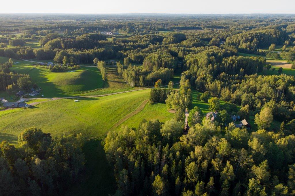
The observation tower was built for the first time in 2007, and after amortization, it was reopened as a new building in the summer of 2023. In winter the parking area and access to the tower are kept clear of snow. Stunning views of the semi-natural landscapes and forests of Karula open from the top of the tower.
Observation tower is situated in Karula National Park. Further information can be obtained from the Environmental Board +372 662 5999; info@keskkonnaamet.ee
Contact
Telephone: +372 782 8350
E-mail: info.karula@rmk.ee
Object type: observation tower
Location info
Location : Võru County, Karula National Park
Mähkli village, Antsla municipality
Navigation instructions : Drive 8 km from Antsla towards Haabsaare, turn right 50 m after the Haabsaare bus stop (signs “Karula rahvuspargi külastuskeskus 7 km”, “Saru 20 km”). Drive 3.2 km on Haabsaare–Saru road to the sign “Mäekonnu vaatetorn 1 km”. Drive 1 km to the parking area of the Mäekonnu observation tower. The tower is 100 m from the parking area (follow the sign). The campfire site is next to the observation tower.
By clicking on the map it will open the map application larger in a new window.
Telephone:
+372 782 8350
E-mail:
info.karula@rmk.ee
Object type:
observation tower
Location info
Location:
Võru County, Karula National Park
Mähkli village, Antsla municipality
Navigation instructions:
Drive 8 km from Antsla towards Haabsaare, turn right 50 m after the Haabsaare bus stop (signs “Karula rahvuspargi külastuskeskus 7 km”, “Saru 20 km”). Drive 3.2 km on Haabsaare–Saru road to the sign “Mäekonnu vaatetorn 1 km”. Drive 1 km to the parking area of the Mäekonnu observation tower. The tower is 100 m from the parking area (follow the sign). The campfire site is next to the observation tower.